Showing posts with label backpacking. Show all posts

Wednesday, July 17, 2013

Rocky Mountain National Park Backpacking Trip: North Inlet Trail to Flattop Mountain

The end of our six week trip across the west was in sight.  After spending time in seven national parks and visiting a remarkable variety of terrain, it was almost time to head home.  Thank god we had saved the best hike for last!  

Our last foray into the Rocky Mountains was to be a five day, four night backpacking trip into the heart of the wilderness.  This was the only hike on our trip that I had secured a permit reservation for before leaving home, having successfully navigated the antiquated application process.  A lot of credit is due to the backcountry office in RMNP for being eager to work with applicants to help them find an available hike.  Other parks I have applied through require you to fax or mail in your proposed itinerary months in advance.  Then, if any portion of your trip runs into an unavailable campsite, they notify you several days later that your request has been declined.  This invariably, happens every time.  These parks don't provide you with any clues as to which portion of your trip might have been the problem.  It's a bit like playing battleship.  

The folks at Rocky Mountain still ask you to mail in your reservation request.  Nothing like 18th century technology in the year 2013!  The good news was, when my requested trip wasn't available exactly as I had requested it, they mailed me a slightly altered trip plan and asked me to call them if I wanted to discuss possible variations to this reservation.  The revised plan still made it possible for us to spend five days in the same part of the park, while still visiting the same attractions.  With a nearly ideal hiking trip reserved, we had been looking forward to this backpack since May.

The night before our hike was a wet and nasty evening of weather.  Needless to say, we were delighted to wake up and find blue skies and a bright sun overhead to help us dry our gear.  We packed up slowly, taking care to dry each piece of equipment out before packing it up.  After all, wet gear is bound to be heavier to carry!

By the time we finally reached the trailhead it was after 11 am.  It had taken us five hours from the time we woke up to eat breakfast, pack and drive to the trailhead!  Thankfully, the day's hike would not be too tough.  Our first night's destination was the Big Pool Campsite, reached by a five mile hike that ascended a little less than a thousand feet.  It was a good thing we had an easy day ahead of us, as our packs were brutally heavy.  We had to carry five days worth of food, and the park required hikers to carry heavy bear canisters needed to keep food safe from nighttime bear raids.  We also were carrying heavy, warmer clothes for the cold weather above ten thousand feet.  

We set off on the North Inlet Trail under partly sunny skies with a light breeze..  The trail followed a two-track still used by park vehicles across a pleasant meadow.  We passed private ranch land on one side.  The wooden fences and grazing horses lent a western aesthetic to this section of the trail.  Meadows of wildflowers lined the path.  Hummingbirds darted across the trail and chubby groundhogs munched on the tall grasses.  

After passing the Summerland Park campsites, the trail gradually became more wooded.  The shade from the stands of tall pines trees was more than welcome, as we struggled up hill with our heavy packs.  Large rock outcrops began to become more common along the trail as we climbed.  


The North Inlet Creek began to put on a whitewater show off to the side of the trail.  The soothing sound of crashing water would be a constant soundtrack for much of our backpacking trip. 

Cascade Falls came into view a little over half-way through our day.  This tremendously impressive waterfall featured one large, thundering drop, and a series of smaller falls and whirlpools both above and below.  It was a popular destination for day-hikers, and folks lounged about the area on the rocks in the sun.   The trail would be much quieter above the falls.  


Above the falls, the trail climbed much more steeply.  We found ourselves hiking over large stone steps expertly placed by the hard-working trail maintenance crews.  Many of the workers were out on this fine Saturday afternoon.  It looked like terribly hard work, hauling chainsaws and other equipment miles on foot in order to keep the trail functioning.  

Eventually, another waterfall came into view.  The large, deep pocket of water beneath the falls made it obvious that this was The Pool.  The spur trails to both campsites were located only a few feet beyond the waterfall.  We found the first site to be already occupied and quickly made camp at the second one.  The spur trail to the site climbed uphill for 20 yards or so, providing privacy at our campsite.  We hurried to set up camp, aware that the threatening skies could unleash an afternoon thunderstorm at any minute.  Happily, the weather held for a while, and we we had time to set up camp, go for a swim and filter water for the night.


Big Pool looked as if it might be possible to jump from the far river bank, into the base of the waterfall.  The drop looked to be about 15 feet.  We decided to check out the water more carefully first.  By climbing down the near river bank and cautiously feeling our way upstream we were able to get into the deeper water and swim.  The stream drained snowfields and glaciers high in the alpine country ahead, so it was no surprise to find it colder than Lake Superior.  After a quick swim, we were both chilled and decided to abandon jumping from the cliff on the other side.  

The first of a couple of thunderstorms rolled into the valley around early evening.  We holed up in our tent with a couple of good books and waited out the storm.  High in the mountains, the thunder sounded more threatening, and the lightning looked closer.  The storm broke about an hour before dark, giving us just enough time to fix some dinner and hot chocolate.   


After stashing our bear canister the required 70 steps from camp, we crawled back into the tent and hunkered down for a quiet, but cold night in the backcountry.  Some more rain passed through in the dark, but the storms were done for the time being.  

We emerged from the tent in the morning to find blue skies overhead.  With the promise of dry weather for the time being, we decided to take our time and attempt to dry out the tent and rain fly as much as possible.  We hung the rain fly over a tree in the sun while we made breakfast.  The sun quickly climbed over head, and by the time we were done with breakfast our gear was mostly dry.  We finished packing up and hit the trail around 10 am.  

The hike up to the July campsite was much harder than our first day's trip.  Although it was less than five miles of hiking, the trail climbed over 1,600 feet.  As we hiked, the view quickly became more impressive.  Climbing high above the valley floor, we now had views across to the other side of the valley.  The stark,treeless tundra high above us gradually came into view through the thinning trees.  


As we hiked, the skies quickly turned dark.  The air higher up in the mountains was colder, and a light rain began to fall.  We stopped to pull out our pack covers.  What was once a pleasant, sunny day had now become a dark and ominously gray afternoon high in the Rockies.  

The last stretch of trail for the day was a tiring series of switchbacks that climbed steeply above 10,000 feet.  A lush,  open meadow gradually came into view across the valley.  A picturesque waterfall fell gently over a slanted sheet of rock, almost like a natural water-slide.  Alpine wildflowers were bloomed throughout the meadow.  


Right before we reached the July campsite we passed a foreboding sign on the side of the trail.  The sign warned of the dangerous conditions that could be found beyond this point:


We joked that the mountains must be like the honey badger.  The sign did have the intended effect of causing us to feel more cautious about the high country.  

The spur trail up to the July campsites was a difficult and steep climb over wet, slanted rocks.  Not wanting to climb uphill any more than necessary, we took the first campsite we came to.  Our site sat on a steep hillside under some massive pine trees. Beautiful Hallet Creek rushed down the mountainside mere feet from our campsite.


The on and off rain showers stopped for a while, so we set up camp and started to filter water.  The water filtering was interrupted when gusty winds began to blow through the campsite, driving plumes of cloud and mist.  The clouds were like delicate tendrils, twisting in the air overhead.  Each time the wind changed direction, a wave of cloud would plunge downward, soaking a small stretch of forest in water.  We retreated to our tent and read for a while, waiting for a break in the weather.

Eventually, the rain stopped, and we set about making dinner.  The early evening air was already alarmingly cold, and it seemed as if the sun was long gone, even though it wasn't yet night.  We cooked up a pot of red beans and rice, the perfect meal for such a cold night.  After eating dinner, we retired to the tent early.  The plan was to get up before sun-up and day-hike up to the summit of Flattop Mountain and back before breaking camp.  

This was my first night sleeping above 10,000 feet of elevation, and to my surprise, the altitude seemed to effect me.  Around 1  am, I awoke with a start to the sensation of suffocating.  After a few deep breaths, I felt normal again, and attempted to go back to sleep.  The process repeated itself for the next hour or so.  Recalling the dehydration can be a major factor in altitude sickness, I fished out a bottle of water and forced myself to drink all of it.   It seemed to work, because by 2:30 I was asleep again.

The alarm sounded at 5 am.  I don't think I had been asleep long enough to feel tired or groggy.  Plus, the excitement of hiking above tree line was enough to overcome any fatigue.  We fixed a quick breakfast in the cold, pre-dawn air.  We stripped our backpacks down to only the essential items: rain gear, warm outer layers, first aid kit, food and water.  Everything else stayed behind in the tent during our climb.

The trail crossed Hallet Creek on a precarious wooden plank that had broken in two.  We managed to slide down one side of the plank, and then carefully side-step up the other without falling in the frigid creek.  Within minutes, we were above tree-line and climbing steeply up switchbacks.  The morning air was cold, but the exertion of ascending 1,500 feet in three miles was enough to keep us warm at first.  The views of the valley below rapidly became spectacular.  


As we broke out onto the exposed crest of the Rockies, the air grew brutally cold.  A strong wind blew across the open tundra, and thick clouds drifted over the mountains, obscuring the view in various directions.  Beneath our feet, the tundra was covered in wildflowers.  There was a greater variety of wildflowers here than anywhere else on our trip.  The hardy, little flowers seemed able to grow in the harshest conditions.


As the clouds drifted by, we were treated to occasional glimpses of the valley below and the surrounding mountain peaks.  


I was soaked in sweat from the tiring climb, and the cold wind quickly chilled me.  I stopped to put on all of the clothes I had brought with me.  Some of the rock cairns that marked the path across the open tundra were taller than I was.


As the trail climbed above 12,000 feet of elevation, the simple task of putting one foot in front of the other became exhausting.  On several occasions I found myself doubled over at the waist, hands on my knees.  The altitude can't be affecting me this much, I thought, people climb mountains that are 14 and 15 thousand feet!  Our pace slowed to a crawl as the trail turned away from the precipice and climbed straight towards the summit, and into a cloud.  

The wildflowers vanished with the views, and it now felt like we were hiking across the surface of the moon.  After passing the junction with the Tonahutu Trail, which was closed due to the Big Meadows Wildfire, we ascended another third of a mile before reaching the summit.  Thick clouds blocked the view in all directions.  We sat down on some large rocks and ate a snack.  Once our breathing returned to normal the altitude didn't seem so draining.  I had hoped to take the  off-trail scramble to the summit of Hallett Mountain, but decide against it when I watched another party of hikers walk off into the clouds and disappear.  The north and south faces of Flattop were steep cliff-drops.  Getting lost in the fog could have disastrous consequences.  We asked another hiker to take our picture at the summit.


Disappointed by the lack of views from the summit, but proud of ourselves for climbing to the continental divide at 12,324 feet above sea level, we started the descent.  Hiking downhill was remarkably easier, and the effects of the altitude passed quickly.  We soon emerged from the clouds and were rewarded with astounding views of the lush, green valley below, and the rocky and snow-covered mountain peaks around us.  


As we hiked back through the alpine tundra we were greeted by the hill-pitched shriek of the pikas that inhabited this bizarre landscape.  A member of the rabbit family, these small animals live above tree-line all year long, even in the long cold winters.  Pikas accumulate vegetation in the gaps beneath rocks all summer long to live of off during the winter.  They wrap their plants in a poisonous flower that acts as a preservative.  Pikas have little, rodent- like faces, but huge ears that are disproportionate to the rest of their heads.  

The descent back down the switchbacks was hard on the knees, but easier on the lungs, and in no time we were back below tree-line.  A rotund Yellow Bellied Marmot scurried across the trail at one point, looking alarmed but curious of our presence.

We returned to our campsite at July, exhausted.  We took a break to eat lunch and pack up camp.  Our campsite for this night would be 1,300 feet below, at Porcupine.  After taking our time to eat, and catch our breath, we strapped on our heavy backpacks and began the descent.  The sun was now shining brightly overhead.  


We arrived at our campsite at Porcupine before 2 in the afternoon.  We threw up the tent, filtered enough water for the night, and crawled into the tent thoroughly exhausted.  We had made camp just in time to wait out another bombastic thunderstorm.  We dozed in the tent for three hours, only waking up for the particularly loud thunder.  

When we crawled out of our tent around 6 pm, the skies had cleared and it was a beautiful night.  Less exhausted, we discovered that we had one of the most beautiful backcountry campsites we could recall.  It was situated right on the shores of North Inlet Creek, in a stand of pine trees.  The park had provided wooden benches to sit on and even a fire ring.  It looked as if trail maintenance crews had left us a pile of firewood cut from fallen trees. 

We fixed mac and cheese for dinner and enjoyed the first beautiful night on our hike.  Mary managed to get a solid fire going, and we sat around the fire and chatted as the day light faded.  The forest seemed tranquil on this gorgeous night.  


The moon rose brightly through the trees as we watched the fire wind down.  We crawled into the tent eager for a long,restful night of sleep after such a tiring day of hiking.  

We slept in until 8 am, and then read in the tent for another two hours.  We had the same campsite reserved for another night and were looking forward to a relaxing day.  After a leisurely breakfast, we packed our backpacks for another day hike and headed off down the trail.  

The plan for this hike was to take the side trail to Lake Nokoni for a pretty lunch spot.  The trail dropped steeply away from the North Inlet Trail, passing thundering North Inlet Falls. 


Past the falls, the trail climbed relentlessly for over two miles, through a series of steep switchbacks.  We found the hiking to be much harder than we were expecting, but the expanding views kept us going.  

It didn't appear that many people used this trail.  The forest seemed eerily still here.  A mule deer shot across the trail and nervously watched us pass from below.  Near the top of the climb, we found amazing views of Flattop and Hallett, as well as many unnamed peaks on the other side of the valley.  The trail climbed through another beautiful alpine meadow before reaching the shores of Lake Nokoni. 


The lake itself was an absolute gem.  Lake Nokoni was walled off on the far side by the imposing mass of Ptarmigan Mountain.  its waters were a mesmerizing shade of blue, likely from glacial silt deposited over the years.  Mary was brave enough to  go for a quick swim in the crystal clear water.  She said the water was the coldest she had ever been in.  We ate lunch on the shores of our own private alpine lake.  


The return hike to camp was mostly downhill and went by with ease.  We ate our last dinner underneath another stunningly beautiful evening sky.  We headed to bed early, enjoying the quiet of the forest during the night.  

We got up at 5 am in the morning and broke camp quickly.  We had the trail to ourselves most of the way out in the morning, and were treated to the reflection of a beautiful sunrise on the surrounding mountainsides.  The morning air was cool, and we covered the 6.8 miles in a little over two hours.  


Our backpacking trip through the Rocky Mountains was one of my favorite trips we have taken.  We were able to experience stunning mountain views, peaceful pine forests, raging mountain streams and waterfalls, and above all, wonderful solitude.  This is a trip we are both certain to think back to for years.


Tuesday, June 25, 2013

Bryce Canyon: Riggs Spring Loop Backpack

 The Riggs Spring Loop departs from Rainbow Point, on the southern end of Bryce Canyon National Park.  The trail makes an 8.8 mile loop into the wilderness below the pink cliffs, dropping over 1,700 feet as it winds through the dense forest, only to climb the same elevation on the other side.  We were in the mood to enjoy the solitude and the cool, breezy weather for a while longer before heading to the warmer climate of Moab, so we reserved campsites for two nights on the loop.  This would leave us with three short hikes and plenty of time for reading and relaxing in the hammock.  

Knowing we had a short first day's hike of 1.6 miles, we slept in  before packing up camp and stopping into Ruby's Inn for a big breakfast.  We were finally stepping onto the trail at Rainbow Point around 11 am.  Rainbow Point sits at over 9,100 feet of elevation, resulting in tremendous views and cool, breezy conditions.  

The trail to Yovimpa Pass, our first night's destination, was steeper than we expected.  The path switch-backed sharply down the face of an open slope.  The loose rocks and gravel beneath our feet made for slow, precarious travel.  We gradually descended into an open forest of large trees, many of which still bore the signs of having suffered through a forest fire at some point in the past.  Occasional views to the south provided glimpses of the pink cliffs directly beneath the ridge we were traversing, and more distant panoramas of the tortured landscape of the Grand Escalante Staircase.

Shortly after departing this fire-impacted section of the forest, we arrived at Yovimpa Pass.  A gravel road not open to cars intersected the trail at the pass.  Only a small wooden sign for the campsite gave away that this was where we were to camp.  We examined the area and decided to pitch our tent beneath a gigantic ponderosa pine tree.  The surrounding area was an opening within the forest.  Scattered downed trees littered the hillside above us.  The Riggs Spring Trail appeared to drop suddenly off of the ridge past here, giving our campsite ideal views to the  south.  

We lazed away the afternoon reading.  It was one of the coolest days since we had been in the park.  The air couldn't have been warmer than 75 degrees. 

 A little after five, three more hikers arrived at the campsite, making the steep climb up from below.  We had expected to have the campsite to ourselves for the night, but one of the men from Arizona said that the park grants permits for 6 people at this site each night.  This theory was shot down when a young couple from Boston hiked in a couple hours later, saying they had a permit too.  Fortunately, both parties bushwacked off-trail to find campsites, and although we could occasionally hear them, we had a reasonable amount of privacy for the night.

The air quickly grew cold after dark and we struggled to keep warm in our sleeping bag.  The forest was wonderfully silent as the brightest full moon of the year rose overhead.  I awoke on more than one occasion thinking that I had overslept and missed sunrise, only to realize that the blinding light overhead was just the moon.  

We slept in until it was warm enough to justify leaving our cozy sleeping bag.  After a breakfast of grits and  coffee we packed up and headed down the trail.  Our destination for the night was the Coral Hollow Campsite, less than four miles away.  This should have provided for another easy day, or at least we thought.  

The trail dropped sharply down the ridge for the first mile or so.  The loose rocks and gravel continued to make for slow going.  Eventually we were off of the ridge, and for the next mile or so we had an easy stroll through a beautiful forest of ponderosa, fir and aspen  trees.  The steady breeze blew through the aspen trees, shaking the little green leaves.  We thought that they looked to be waving at us as we hiked by.  Aspen certainly seem to be some of the friendliest trees to hike under!

When we reached the Riggs Spring Campsite we took off our packs for a break.  Riggs Spring would be our last source of water on the backpack, so I planned to filter enough to last us the rest of the trip here.  Mary sat with the packs while I wandered off to find the spring.  Riggs Spring was a small pool of clear water surrounded by mud at the edge of the forest clearing.  The park had built a small fence around it, I assumed to help hikers locate the tiny watering hole.  

I found a well-placed log to rest on while I filtered the water.  I had only been sitting there for a couple of minutes when I heard an alarming crashing sound behind me.  I spun around, ready to confront a bear, or other woodland creature.  Whatever caused the sound was not visible, but the trees and leaves were still shaking next to me.  The man from Arizona the last night had said that his wife had seen a mountain lion at Riggs Spring during a previous visit.  The park service had warning signs everywhere that a mountain lion had entered Sunset Campground last fall.  The park ranger in Zion National Park had told us that, although Utah hasn't had problems, "mountain lions in the Sierra Nevadas occasionally stalk and kill hikers."  

With these thoughts racing through my mind as I eyed the dark forest, I decided strength in numbers was a good idea.  I walked back to where Mary was and asked her to get our the bear spray, just in case.  We moved our packs to where I was filtering and made a point to talk loudly while I finished filtering.  The culprit behind the commotion never gave himself away, and we finished filtering, ate a quick snack and got back on the trail  As we hiked south, we both had the feeling of being watched.  The occasional noise to our right would cause us both to stop and peer into the forest, expecting to see something moving.  Heavy, gray clouds moved into the area, and a cold wind blew through the forest.  Mary remarked that if we in Michigan, we would assume it was going to rain, with air like that.

We passed the Riggs Spring Campsite, not bothering to to look at our trail map.  After all, this was a loop hike, we figured. One of the campfire rings in the group campground was filled with giant pinecones, piled high in a perfect geometric formation.  Mary joked that it was "bear art" - the work of bored forest bears with limited mediums with which to express themselves.  

As we hiked south the trail began to grow fainter and fainter.  It suddenly vanished at the edge of a giant wash, the forest tore up by the terrible violence of flash floods in the past.  We climbed down into the wash and began to search for where the trail resumed.  Some strange equipment was sitting on the opposite bank.  I recognized one device as an anemometer, a machine that measures wind speed and direction.  I wasn't sure what the other equipment was for.  

We followed the wash for a while, until a path appeared again.  Confident that we had found the trail, we bounded off down the path, eager to reach our campsite for the night.  After about ten minutes of hiking, we suddenly arrived at a fence.  Evidence of ranching was all around, and a sign indicated that we had reached the park boundary.  Beyond this point was National Forest Land.  A ladder had been installed over the fence, much like on sections of the AT in Vermont.  We wondered if we were supposed to climb it.  The guide book I had used hadn't  mentioned ranch land, fences, or leaving the park.  

Frustrated, I pulled out our topo map, and suddenly felt like a complete idiot.  The trail to Corral Hollow had turned off by the spring.  We had followed another trail that ran out of the park and into National Forest Land.  We angrily turned and resumed hiking in the opposite direction, hoping we could follow the faint path all the way back to the spring.  I couldn't help but wonder what the purpose of this trail was.  The dried-up remains of cow patties littered the forest floor- evidence that the ranch livestock must get into this area some times.

We successfully found our way back to the spring, but didn't see any signs of the trail turning northeast from here.  We decided the turn-off must be north of here.  We hiked for about ten minutes past the spring, annoyed to be covering the same section of trail again.  The trail never appeared.  We finally took our packs off and sat down for a break.  We were both cursing the park service for a such a poorly labeled trail junction.

Mary thought she had seen a sign on the opposite side of the wash, and maybe this would show where the trail picked up.  I stayed with the packs while she climbed the steep banks to have a look.  She was gone for about ten minutes, before she came walking back on the same side of the wash as I was sitting.  She had found the trail!

Mary had followed the wash for a while, looking for a sign.  She never did find the sign, but she found a clear trail with many boot prints.  She followed it back towards the other side of the wash until it intersected with trail we had been on, sitting one of her trekking poles down to mark the spot.  It turned out the trail junction was exactly where it was shown on the map.  If we stood facing in the direction of travel of the trail we were on, it was completely concealed by the tall grasses at the junction.  Once we turned our bodies and looked down it, the path was clear.  We had wasted more than an hour wandering around the forest looking for it.  

The path now clear, we resumed hiking.  The trail climbed steadily away from the junction, passing through a dense forest with no views.  We struggled to find the trail again where a giant tree had fallen and wiped out the trail.  This time, it only took us a couple minutes of wandering around to pick up the trail on the other side of the tangled mess.  No wonder the ranger had warned us that Bryce wasn't a good backcountry park!

A couple of hikers passed us headed in the opposite direction as we climbed.  Where were they when we couldn't find the trail, we wondered!?!  

Eventually the sing for Corral Hollow appeared.  We were delighted to be done hiking for the day.  What was supposed to be a short, easy hiking day had turned into a frustrating and long hike.  Corral Hollow was a small campsite, with room only for a couple of tents.  A "hollow' is like a ravine, or gully.  Corral Hollow was a fairly small level area, with steep walls rising on all sides.  Pink Cliffs were visible directly above us, and giant trees lined the trail through the hollow.  

We set up camp quickly, eager to relax.  We did not see another soul while we were camped at Corral Hollow.  The woods were eerily silent during the night.  Dark clouds drifted in during the evening, and we wondered if we had erred in not brining our rain fly.  One plus to the cloud cover was that it trapped the day's heat at least.  The air remained balmy throughout the night.  The moon passed overhead during the night, its intense white light shrouded by drifting clouds.  

We were relieved when morning came and the skies were clear.  We ate quickly, packed up camp, and were on the trail before 8 am.  The hike up from Corral Hollow to Rainbow Point, 3.6 miles, was by far the most spectacular section of the hike.  The trail quickly ascended to a ridge with stunning views of the Grand Escalante Staircase in the distance, and the dark green forest in the foreground.  The rest of the hike stayed on this ridge, allowing for steady views and consistent breezy, cool air.

By 10 o'clock we were making our way past tourist in flip flops wandering the woodchip-covered trail near Rainbow Point.  Our two night backpack on the Riggs Spring Trail had turned out to be much harder than we expected.  Our reward for the slow travel on the poorly marked and lightly used trail, though, was two nights of solitude in a beautiful, dark forest.  We never saw any large mammals during our backpack, but we had the distinct impression they were around.  We even found some mountain lion scat on the trail in one section of the trail.  The wilderness below the rim was the perfect answer to the hordes of tourists packing the viewpoints above.

Note:  The little green guy in the bottom picture is a short-horned lizard, which was saw tons of on the trail.    


Sunday, June 16, 2013

West Rim Backpack

The West Rim Trail in Zion National Park runs south from the Lava Point trailhead in the Northwest corner of the park.  This trail starts out at over 7,000 feet of elevation and, following the Horse Pasture Plateau, winds it way gradually towards Zion Canyon.  Upon reaching the west rim of the canyon it rapidly switchbacks through stunning side canyons all the way to the floor of Zion Canyon at the Grotto Trailhead.  This is arguably the premier backpack in Zion. We were really hoping to have the opportunity to hike the West Rim.

Taking on the West Rim entailed securing one of the limited permits issued for backcountry campgrounds in the park.  About half of the backcountry campsites in Zion are available for reservation far in advance of the intended trip.  The rest of the sites are available on a first-come first -served basis starting at 7 AM the day before the planned hike is to begin.  By visiting the Wilderness Permit Page on the Zion Webpage back home, I had determined that we had no shot of reserving a campsite in advance.  I honestly don't know who the people are that are able to plan their trips so effectively so far in advance as to nail down the exact nights and locations of their backpacking trips months before leaving home.  More power to them, I guess, but I am certainly not one of them.

That stated, our remaining choice was to shoot for a walk-in permit the day before our hike.  I set the alarm for a pre-dawn wake-up on Thursday morning.  I was in line outside the visitor center by 6:15 AM.  I had decided that forty-five minutes was the maximum amount of time I was willing to commit to waiting in the dark.  Five people were in line when I arrived there, and judging by the camp chairs and blankets, they had been there a while.  It would turn out that all of them were seeking permits to thru-hike the narrows, or enter the "subway" a super-hard slot canyon few visitors ever reach.

My gamble paid off, and by 7:30 I was out the door with permits in hand.  I was able to secure my first choice of campsites for both Friday and Saturday nights.  This would allow us to segment the 14.2 mile trail into three very short stretches.  This seemed like a really easy hike in comparison to our other wanderings, but backpacking in the desert was still a very new phenomenon to me.  I was afraid that the mid-day heat would overwhelm us, or that we would run out of water high on the plateau, or that a rattlesnake would bite or us, or - well, suffice it to say that I wanted to be cautious on our first desert backpack.  Besides, nothing wrong with having some time to kick back and relax in the hammock somewhere quiet!

We spent the rest of Thursday relaxing in the shade and preparing for our backpacking trip.  There were some exciting new details to consider with a desert trip.  It would seem that we would not need a number of items, seeing as it doesn't ever rain here.  We decided to leave behind our rain fly to our tent, our tarp, our rain gear, our pack covers, and any clothing that we weren't going to wear while hiking.  All of this was intended to balance out the added weight and space of carrying additional water.  

We usually only leave a trailhead with 6-7 liters of water for the first day of a backpack.  Finding more along the way hasn't been an issue in the East.  The map indicated the presence of a spring near our first night's campsite, but again, being nervous about the reliability of this water source I wanted to carry enough in case it wasn't flowing.  The compromise we settled on was 10 liters.  We also decided to carry the bear-canister for our food, even though bears aren't much of an issue in Zion.  Although it added weight, it would keep the squirrels and chipmunks at bay.

The last issue we needed to resolve before such an undertaking was finding a shuttle to the trailhead.  Lava Point lies about 45 minutes by car north of Springdale.  I had taken the liberty of reserving a ride on a 7 am shuttle with the Zion Adventure Company a few weeks back in the hopes that we would succeed in securing a walk-up permit.  The shuttle service wasn't cheap, but the option of doing this hike as a thru-hike was worth every penny.

My cell-phone alarm went off at 5 am Friday morning.  Neither of us had slept particularly well during the night.  A steady blast of wind came down through the canyon throughout the night, tugging at the tent stakes in all directions.  We were forced to pack up camp and finish preparing the backpacks in the pre-dawn dark while fighting with the gusty winds.  The good news was, at least it wasn't hot.

We made it to the Zion Adventure Company's parking lot with enough time left to apply sunscreen and double check the packs for last-minute additions.  The shuttle left promptly at 7 am.  A large van, either a Sprinter, or like one,  with extraordinary head room, it had room for more than ten hikers.  This particular trip took three couples to their hikes.  One couple was headed the trailhead for the Wildcat Canyon, another trail that could be linked with West Rim for a longer backpack.  The other couple, young, athletic looking folks with European accents, was headed for Lava Point as well.  They were planning to hike the West Rim as a day hike - a very long one.

The shuttle ride was worth the price alone.  John, our driver, gave us a narrative of the area's history and significance of certain locations - including his own personal cabin and the giant boulder that crashed through his fence in the middle of the night.  John said he had laid awake for several nights afterwards imagining that each sound was another rock headed for his home.  Stories like this remind me of how lucky we are in Michigan without natural disasters.  The ride also took us by a road that lead to the filming location of Butch Cassidy and the Sundance Kid.  

The road north towards the Kolab Reservoir was a wild one.  It wound through a portion of the Southwest Desert before climbing high into the desert plateau.  Gradually, the vegetation changed over to pine, and the hillsides took on a green hue.  We were all surprised to find the terrain so close to the desert to be so full of growing things. John told us that he often sees elk in this area.  Our ride was briefly interrupted by a llama, as the shaggy, white haired fella wandered into the middle of the road and just stared at us for a time.  I had the impression that we might be the only car to come this way that day.  

As we approached Lava Point, the road became rough and rutted.  John paid this no mind, flying down the sandstone-red path at alarming speeds.  Several of the bumps in the road sent us flying out of our seats.  Mary remarked that this mighty be the reason for the tremendous head room!

Eventually we reached the trailhead, and we were on our way.  The trail was surprisingly mild on our first day.  It climbed very gradually through a lush forest, interrupted occasionally by hills of bushes and cacti.  Many of the cacti had bright colored flowers opened in the direction of the sun.  The hillsides were covered in many places with a variety of other wildflowers.  I am not great at wildflower identification, but I did notice Indian Paintbrush and Honeysuckle in many places.  

The weather high on the plateau was heavenly.  The added 3,000 of elevation had the effect of lowering the temps by at least 10 degrees, and a pleasant breeze drifted through the wilderness.  Occasional views of distant mesas and canyons peaked through the vegetation.  

We arrived at campsite #7, our home for the night, before noon.  So much for a rough day!  The site had a couple of giant  pine trees on either side of it, providing for consistent shade on some part of the site at all times.  The views were somewhat limited from here, but the hill directly below us was covered in cacti - all clad in brightly colored flowers.  It was like we had our own flower garden.  

The search for water took a few minutes. We ended up locating the spring about 3 tenths of a mile from our site, down a side spur trail for campsite #6.  The spring, called Potato Hollow on the map, turned out to be a pleasant place to relax while filtering water.  Literally and oasis in the desert, it was the only source of water for miles.  Birds swarmed around the tall marshy grasses on its edges throughout the day.  The most common bird we sighted was the tree swallow - its bright green back flashing in the sun as it darted through the air and to the surface of the water.  

With plenty of water available, we spent the afternoon and early evening relaxing in our hammock, strung between two young Aspen Trees, in a thick stand of Honeysuckle.  We read books and relaxed in the shade, even tolerating the steady stream of bees that came by to visit the flowers near us.  Occasional hummingbirds zoomed by, and one looked like he was thinking about trying to feed from our hammock.  Maybe the red color confused him!

In the evening the winds picked up and the sun dropped below the hills to the west.  The air rapidly grew cold.  We fixed a boxed meal of couscous for dinner.  The chocolate bar we packed melted - covering everything in the food canister with a thin layer of chocolate.  We ended up scraping the dried-on chocolate off of many of the items as our desert.  So much for my theory that high percentage chocolate doesn't melt.  In the desert - everything melts.  Still, it was hard to complain.  We had a beautiful meadow to ourselves for the night.

We both intended to stay up late to watch the stars, but the cold night air coupled with our poor night of sleep the previous night lulled us to sleep within minutes of darkness.  During the couple of times I awoke during the night to shift sleeping positions I was treated to a blanket of stars that stretched from one horizon to the next.  The air was cold, and the world outside our tent was wonderfully quiet.  

In the morning we woke to the sun's hot rays streaming through the tent, directly onto our faces.  We prepared some grits for breakfast, with plenty of hot coffee.  I went back to the spring to filter more water.  Our campsite for Saturday night would not have any water source.  Mary packed up camp while I fetched water, and in no time we were ready to hit the trail.  Loaded down with 15 liters of water - enough for the rest of our hike, we hoped, our packs were suddenly very heavy.  

The trail threw us a bit of a curveball to start day two.  It left Potato Hollow via a steep and steady switchback up and over a green ridge.  We were both huffing and puffing within minutes.  Eventually, we did break out onto the ridge, earning views in several directions.  Looking behind us gave us a neat perspective on our campsite for the night and the surrounding area.  

The trail followed the edge of the plateau closely the rest of the day, affording remarkable views of the towering temples and deep, dark canyons on both sides of us.  More distant and prominent mountains could be seen to the West.  We passed a group of hikers - the first we had seen in 24 hours, near the junction with the Telephone Canyon Trail.  We both marveled at how none of them seemed winded, or dirty, at all.  We always feel like we are covered in filth, soaked in sweat and exhausted while backpacking.  Many of the hikers we have encountered on the trail out here must run triathlons in their spare time - they never look tired or bothered by the heat!

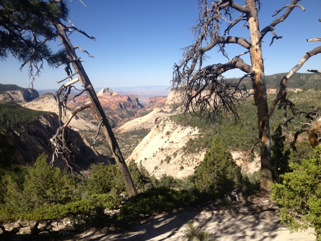
Passing the junction with the Telephone Canyon Trail, the West Rim Trail passed through an open scrubland that looked to have suffered through some forest fires.  The views to the west were beyond description.  Looking west from the plateau had the feeling of standing on the surface of the moon, or an alien planet perhaps.  

We were delighted when we found the post for campsite #5 near a thick stand of pine trees.  The short spur trail lead to a perfect little site - set in a stand of trees providing shade, and with views into Telephone Canyon, and across the Narrows to The Mountain of Mystery.  We set up our camp and spent the afternoon relaxing in the hammock and reading in the tent.  

In the evening, we were treated to a stunning sunset a short walk from our tent.  The sun melted, like butter, into the alien landscape of rounded gray temples, towering sandstone cliffs and distant mountains.  The whole terrain was awash in a bluish light as the sun vanished for the night.  

The air that night grew cold, and the winds raged across our narrow little spit of land.  We were wishing we had packed more clothing as we crawled into the tent for the night - but once in our down sleeping bag we slept comfortably.  

We awoke in the morning in time to watch the sunrise over the green, gentle slope of the Mountain of Mystery in the East.  After a quick breakfast we were back on the trail.  The last day promised the most spectacular scenery.  

The trail wound its way around the remainder of the Horse Pasture Plateau, providing steady views to the West and eventually South.  The dark chasm of Behunin Canyon dominated the scenery for a while.  At the junction where the Telephone Canyon Trail re-joined the West Rim Trail we began a rapid descent down the face of a sheer cliff.  The trail was only 3-5 feet across in most places, and the drop offs into the canyon were terrifying.  We picked our steps carefully as we descended the steep trail.  

Eventually, the trail arrived at a bridge across the remaining depths of a side, "hanging" canyon.  We stopped for a snack break just beyond the bridge, before beginning the climb up the other side of the canyon.  The trail switchbacked through a red sandstone world back out of the canyon, reaching a gray colored rock surface.  We were treated to a fairly level walk across open, rocky terrain for a while.  Signs installed by the park service aided in locating the trail.  It eventually resumed descending, and in no time we were arriving at Scout Lookout.  Scout Lookout is where the quiet solitude of the West Rim Trail meets to the crowded mayhem of the Angel's Landing Trail.  

Angel's Landing is the most famous day-hike in Zion.  Only a short, but steep climb up from the Grotto, it offers un-equaled views of the canyon floor.  Most of the hike, the part that reaches Scout Lookout is a hard, but safe series of tightly woven switch backs through Refrigerator Canyon.  Called Walter's Wiggles, these switchbacks make this lookout accessible to just about any hiker.  Beyond the lookout, the  half-mile trail climbs out onto a narrow mass of land jutting into the canyon.  The trail had chains bolted into the side of the rock in many places to aid in the climb.  Angel's Landing is quiet famous, partly due to the fact that six hikers have fallen to their deaths since 2004, a fact the park displays prominently on signs at the base of the climb.

I was on the fence about doing the climb, and Mary wanted no part of it.  She agreed to stay with the packs while I explored the trail.  I wasn't sure how far I would get, intimidated by the climb's reputation.  The trail climbed unpredictably, snaking around one side of a mass of rock, before switching to the other side, and then occasionally going straight up and over steep rocks, requiring climbers to hold on tight to the chains and pull themselves up to the next level.  Through all of this, the trail never ventured more than a few feet from the 1,500 foot sheer drop-off to the canyon floor.  

I was happy to find that the "cliff exposure," as the warning signs call it, wasn't as bad as I anticipated.  In most places, it's reasonably safe, as long as you don't go too fast and don't let go of the chains near the edges.  The steady stream of hikers moving in both directions might be the most challenging aspect of the climb.  Most were very responsible,though,  taking turns, and deferring to the down-hill climbers in the narrow spots.  The hike was harder from a cardiovascular perspective than I expected.  In places, the steps were quite far apart, even for my long legs.  

I reached the top in about thirty minutes. My legs were trembling from the workout and my chest heaved with exhaustion.  I stopped long enough to marvel at the view and snap a few pictures before beginning the return trip.  The down-climb was actually easier than I expected.  I elected to sit on my bottom and scoot down some of the steeper sections, while holding on to the cables for support.  In a  few minutes I was back at Scout Lookout .  I only saw one person freak out and turn around on the chains in the time I was up there. 

Reunited with Mary, I was happy to finish our backpack and seek some cold drinks and non-dehydrated food.  We made the descent through refrigerator canyon in short time, and soon were at the Grotto Trailhead waiting for a bus.  My knees are sore after a day that included more than 4,000 feet of descent on mostly hard rock surfaces, but I am delighted with the beautiful experience we were able to have in the backcountry of Zion.  

We decided to check into a motel in Springdale for the night.  We need a chance to shower, wash laundry and buy groceries for the next leg of our trip.  We had an early dinner at Pizza and Noodle - a cool local place with great pizza and air conditioning ( a must).  Tomorrow we leave for Bryce Canyon.  We have thoroughly enjoyed out time in Zion National Park, but we are looking for ward to the cooler temps in the high elevations of Bryce.