Showing posts with label heat. Show all posts

Sunday, June 30, 2013

Arches National Park

After leaving the Needles, we drove north to Moab, happy to be back in the air conditioning in our Jeep.  A fine, white haze seemed to hang over the mountains to the East as we drove.  Mary rolled down the window, took a sniff and declared that it smelled like smoke.  We were a bit alarmed, thinking that there may be a forest fire somewhere nearby.  The road we were on was the only route out of the Needles, however, so we figured we had best keep driving.  Surely the authorities would take some kind of action if there was a fire that threatened the road.

As the path climbed high into the mountains, the views diminished to only a couple of miles, the rest blocked out by white smoke.  We would later learn that this smoke was from distant wildfires in Colorado and New Mexico, blown hundreds of miles across the desert.  By the time we reached Moab, the skies were clear again.

We grabbed a campsite just outside of town, setting up camp as quickly as possible in the mid-day heat. The rest of the afternoon was spent hiding from the heat in the air conditioned public library. 

By 6 PM we decided it was now or never if we were going to go hiking.  The weather was still oppressively hot, but at least the sun had moved off to the horizon in the west, instead of beating down directly overhead.  

The drive into Arches National Park was a beautiful one.  Past the entrance gate, the park road climbed a series of tightly woven switch-backs up an impressive cliff face.  Views into the Colorado River canyon and Moab opened up as we drove.  Frequent pull-outs were provided for photo opportunities along the way.

Eventually, the road broke out onto the flat terrain of Arches National Park, with Moab and the canyon no longer visible.  The La Sal Mountains loomed to the Northeast, patches of snow still visible on their higher elevations.  To the north, a seemingly endless terrain of desert scrublands lent a barren feel to the landscape.

The road into Arches passed many famous landmarks as it made its way deeper into the park.  Arches is a great national park for visitors that aren't able to hike, as most of the attractions can be seen from the road.  Our first destination was Balanced Rock.  Appropriately named, Balanced Rock is a large boulder that appears to be balanced on a smaller spire of rock, likely more than 100 feet above the ground.  The rock is the result of the forces of erosion working on different types of rock at the same time.  The spire is made of a type of rock that eroded  away more quickly, while the boulder is of a more durable material that took longer to wear away.  Eventually, the forces of nature will have their way with Balanced Rock, and the spire will no longer be able to support the boulder.  Someday, it will come crashing to the earth.  

The trail took an easy 0.3 mile path around the rock, providing many interesting view points along the way.  We stopped for photos in a few spots before hopping back in the Jeep and heading to our next hike.

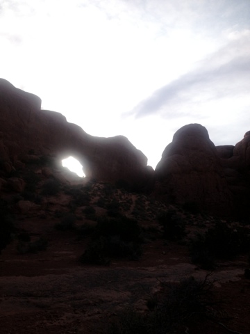
The Windows are a series of arches that are built into rock faces, creating the appearance of "windows" through the rock.  A 1 mile loop trail circles these rocks, mostly crossing open, arid terrain. We took the loop hike in a counter-clockwise direction, and were rewarded with a really cool view of the La Sal Mountains as we climbed the slick rock up and around to the other side of the formation.  

As we passed the windows from the back side, several visitors had managed to climb the the base of the arches.  The abundance of slick rock in Arches makes it possible to climb  just about anything, but getting back down can be much harder than it seems!

By the time we were finishing the loop, it looked like storm clouds were rising over the La Sal Mountains and opening up.  Sheets of rain could be seen draping down to the mountainsides like fingers of pale light.  Framed by the arch windows, it made for a pretty impressive scene.  Walking around the arches at twilight turned out to be a great choice, as the fading sunlight and colorful skies did some really neat things to the rocks.

Our last hike of the evening was the Park Avenue hike.  Early visitors to the park named this section for its resemblance to the tall buildings in New York.  The Park Avenue Trail is a 1 mile path through a small canyon between large fins of rock that resemble sky scrapers.  We left from the higher end, a dubious choice considering the up-hill we faced on the return trip!  The day's light was fast fading, so we only hiked about half of the trail before turning around and making the climb back up the the trail head.  Even the modest, 200 foot climb left us exhausted in the desert heat.

We drove out of Arches with limited daylight left, returning to our campsite for dinner.  Cooking in the dark had its challenges, but at least it was finally below 100 degrees outside!  It was a miserable night of sleep, as the heat never subsided much in our tent.  I was somewhat relieved when it was light out again and I could at least get out of the tent.  

We were back in Arches before 8 am, hoping to take advantage of the "cooler" weather in the early morning hours.  It was only 90 degrees in the park when we started hiking.
  
The Devil's Garden trail is the longest and most challenging hike in Arches National Park, a park not known for difficult hiking trails.  The hike is an out and back trail that visits a number of famous landmarks in this more remote corner of the park.  If hikers take the optional primitive trail back from the far end of the main trail, it becomes a difficult 7.4 mile loop.  We would decide that the main trail was difficult enough in the heat, and only do the 5 mile out and back along the main trail.

The first mile of the trail was a well-maintained pathway, with fences along the sides to keep hikers on the path and off of the fragile cryptobiotic soil of the surrounding landscape.  The path had a number of spur trails that lead to attractions along the way, including Navajo Arch, Landscape Arch, and Pine Tree Arch.  We stopped for pictures at each of these locations.  Much of the trail was delightfully shady during the morning.

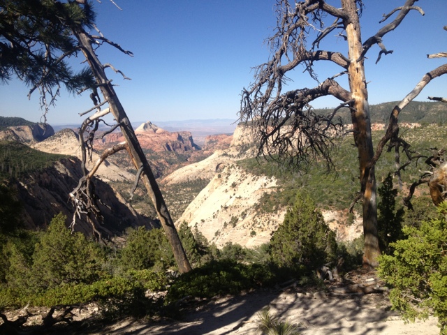
Past Landscape Arch, a thin, spectacular arch that looked ready to fall, the trail suddenly became much more difficult.  A challenging, 100 foot climb up slick rock took us to a higher plateau.  Much of the next mile was spent rock hopping, scrambling up slick rock and walking along the spine of some of the "fins," or large narrow rock formations common in this terrain.  The views were amazing along much of this section of the hike.  I had the distinct feeling of walking along the top of the world.

The last major arch on the hike was Double O Arch.  Double O is a pair of arches that are nearly stacked on top of one another.  Some hikers had managed to climb on top of the arch, which seemed like a bad idea to me.  It was at least a hundred feet straight down, and the arch has to collapse someday!

Beyond Double O, the trail dropped gradually over sandstone ledges, reaching the desert floor.  The rest of the trail to Dark Angel was an easy walk on soft sand through desert scrubland.  Dark Angel is a spire jutting straight out of the desert. Over a hundred feet in heigh, this spire of rock has a shiny black color to it, possibly the inspiration for the name.

The return hike to the trailhead was a bit easier in most places, as it seemed to go more downhill than up.  A few of the scrambles down slick rock made for slow, careful going, however.  By the time we returned to the main pathway, it was almost noon, and the sun was quickly becoming oppressive.  Our packs were both drained of water by the time we reached the trailhead.  

We ate a picnic lunch in the Jeep with air conditioning running.  It was 109 degrees outside in the mid-day heat.  After eating, we headed for the Moab Aquatic Center, the perfect place to survive the hottest heat of the day.  For only $7, we got not only a shower (the first in a quite a few days), but also access to the indoor and outdoor pools, complete with water slide and crazy-high diving boards. 

We stayed at the pools for as long as we could stand to wait for dinner, avoiding the worst of the day's heat.  In the evening, we visited a couple of classic Moab destinations.  We had dinner at the Moab Brewery.  We had purchased a few of their brews at convenience stores across Utah during our trip, and were eager to check the place out.  They had a large selection of vegetarian food, which we enjoyed with a sampler of their microbrews.  Utah has peculiar and difficult to understand liquor laws.  One result is that their beers are all low percentage (below 4), which is very unusual for a microbrew.  That said, they are all very good, and in the desert heat I'm not sure we would want more!

After dinner we stopped at Milt's for milkshakes.  Milt's is Moab's oldest restaurant.  Located in a tiny building a block off of Main Street, they only have a couple of tables and a counter for seating, but fry up burgers, fries, and tater-tots, along with awesome milk shakes.  An oreo shake was the perfect way to wrap up a great day in Moab.  This quirky little town really is an oasis in the desert for outdoor enthusiasts. 

We have one more day in Moab, before we finally head for Colorado and mercifully cooler weather.  We've had a blast here, but are more than ready to escape the heat!


Saturday, June 29, 2013

Canyonlands Day 3: The Needles

We woke up early from the Cowboy Camp and quickly packed up.  We had a long drive ahead of us, and wanted to make sure we got to Squaw Flats Campground early enough to grab a first-come, first-served campsite.

We stopped off in Moab for gas and more ice for the cooler.  We had found that it took about two bags per day in the intense desert heat to keep drinks and produce cool.  By the time we were driving south towards the Needles District, temperatures were already pushing past 100 degrees.  

Driving to the Needles really gave us an idea of just how remote the place was.  Once we left Moab, we didn't see another gas station, or any other business, for that matter, for an hour and a half.  Traffic was heavy on the main highway, but after making the turn for the Needles entrance, we didn't see much in the way of people or cars, either.  

The road climbed high over a mountain pass, the surrounding hillsides lush and green.  Watching the temperature drop on the dashboard thermometer gave me hope for the conditions we would be camping in.  We were hoping to spend four nights in the Needles.  This would give us enough time to do some hiking through the unusual formations.

My hopes of cooler weather turned out to be merely wishful thinking.  The road rapidly descended to the floor of a canyon as we drove west.  The canyon walls were towering and steep on either side of the road, however the road was not completely enclosed in all directions, like in other parts of Utah we had driven through.  Dense stands of cottonwood trees lined the road to one side, an indication that there might be water somewhere nearby.  

We were relieved when we saw a sign for the "Needles Outpost," a store selling gas and other essentials right outside the entrance.  It wasn't until we visited the store later that we would find out just how remote this place was.  

We hurried into the campground to make sure we got a site.  It turned out this wasn't going to be a problem.  Most of the sites were empty.  We found one right next to the bathroom with a wonderful hidden amenity. 

A small trail at the back of our campsite lead through a dense stand of shrubs and small trees, and into a cave.  The cave was actually a slot canyon formed by the towering rock formations overhead.  The canyon was closed off on the other end, and only had a couple of gaps where the rocks came together above, so it functioned like a cave.  In this dark rock tunnel where the sun never penetrated, it was wonderfully cool.

This was an important discovery, because the air in the campground was around 107 degrees.  The sun bore down on everything with an intensity I had never felt before.  We were determined to set up camp right away, so we hauled out the tent and went to work.  The poles and stakes were painfully hot in only minutes of sun exposure.  Putting up the tent became a game of hot potato, and by the time we were done I was soaked in sweat.  

The terrifying heat seemed to threaten to cook everything and everyone in the desert at any minute.  We pulled out the camp chairs and retreated into the cave. The air was at least 30 degrees cooler in the shadowy cave.  We collapsed into our chairs and waited for our breathing to return to normal.  

Mary remembered the sign in the bathroom that warned of problem bears and ravens.  Apparently the ravens have learned to unzip things, and will tear apart a campsite with food in minutes!  With our campsite out of sight, we decided our only option was to haul all of our food into the cave with us for the time being.  

We wiled away the afternoon reading and snacking on our pile of food in the cool cave.  We had several visitors while we were in there.  First, a small ground squirrel scurried into the cave.  He sprawled out his legs, collapsing so his belly was directly on the soft, cool sand in the shade.  He appeared to be panting.  Our daring visitor made a few plays for our food, but I think he was mostly just after the cool shade.  

A little while later a jackrabbit hopped into the cave.  He dug himself a small trench in the sand and flopped down only a few feet from us, and the squirrel.  They were joined by a chipmunk later.  Mary had the idea of putting out a cup of water, which the chipmunk literally dove face-first into, lapping it up!  I had the distinct impression that this cave played a critical role in the survival of several the desert's inhabitants during the hottest hours of the day.

We had planned to go for an evening hike, but the weather just wouldn't cooperate.  At 7 PM it was still over 100 degrees outside.  We took a drive up to the Needles Outpost to look around instead.  The outpost looked to be more like someone's home with a few shelves of canned food and snacks and a couple of coolers of drinks.  Ice was $5 per bag.  Gas was $6.50 a gallon.  There went our idea of taking a drive on the four wheel drive roads!  We immediately resolved to make it back to Moab on the one tank of gas.  

When the sun finally dropped out of the sky, it was time to make some dinner.  The air remained oppressively heavy into the night hours, but the darkness brought out a new set of problems.  Hordes of flies, moths and other bugs came to life after dark.  They made cooking and doing chores around camp into a miserable ordeal.  We ended up eating our pot of chili while sitting in the Jeep with the air conditioning running.  At 9 pm, the dashboard thermometer read 98 degrees!

As we climbed into the tent, hoping we would be able to sleep in such tough conditions, we decided to abandon hiking in the Needles on this trip.  Perhaps in another year, and another season's weather, we will come back.  The area looked fascinating from the road, with a myriad of bizarre rock formations in every direction.  

We fell asleep that night to the occasional pattering of something bouncing off the rain fly of our tent - not rain, but hundreds of insects colliding with the tent in the darkness.  


Friday, June 28, 2013

Canyonlands Day Two

By 7 am the sun's light had crept over the small dome of slick rock behind our campsite, invading our comfortable sanctuary from the previous day's heat.  With the tent quickly becoming a green house, it was time for breakfast.  

After cooking breakfast in camp, we drove to the visitor center to fill up our daypacks with water.  The cowboy camp didn't have water, and the visitor center, about ten miles south, was the closest water source.  We decided to do a few short hikes in the morning while it was still a bearable temperature in the desert. 

For our first stop, we headed for the Mesa Arch Trailhead.  More of a short walk than a hike, the Mesa Arch Trail is a half-mile loop to a picturesque arch on the Island in the Sky Mesa.

The walk only took a few minutes, and the path was well-maintained by the park service.  The arch itself was more impressive than in the photos I had seen.  I was able to climb up to the edge of the rock running underneath the arch, and was surprised to see that there was a drop off of close to a thousand feet immediately beyond.  Photos taken from the right angle captured the vast landscape framed by the arch.   We hung out long enough to take a few photos.  A handful of other tourists climbed the rocks around the arch searching for the perfect photo.

With our warm-up hike out of the way, we drove further across the mesa towards the Aztec Butte Trailhead.  This hike was a more formidable 2 mile round trip jaunt to a couple of archeological sites.  Most of the trail was a level walk through open desert scrubland on a sandy path.  We spotted a young jackrabbit on the side of the trail, munching on a long stalk of grass.  He didn't look to be alarmed by us.

Part way along the path, a side trail branched over the base of a large rock formation.  From this point, we climbed 40 or 50 feet of slick rock to the top of the formation.  The trail crossed the flat, rocky top to the other side and then descended to a cave.  Inside of this cave were remnants of an old granary used by indigenous peoples long ago.  It looked as if they had made bricks out of the clay and stacked them inside of the cave to create a storage space.  

We followed the spur trail back to the junction, and then continued towards Aztec Butte.  The butte was a large dome of gray rock, with scattered sandstone rocks and ledges.  The top of it was perfectly flat, and lined with green vegetation.  The easy trail quickly turned hard from here, as we had to ascend several hundred feet of slick rock at steep angles.  This was the hike when I began to trust my footing on the slick rock, which isn't really slick at all when its dry.  

On the table-flat top of the butte, the trail made a loop around the perimeter, affording views in all directions of the Island in the Sky Mesa, and the towering canyons of the Green River.  Ruins from another primitive structure were to one side of the trail.

The trip down went quickly, aided by a few stretches of scooting on our bottoms to avoid falling down the steep rock.  We made the easy walk back to the Jeep and headed further down the road for another hike.

Our third hike of the morning was to Whale Rock, a large formation of slick rock that resembles a whale if viewed from the right angle.  The trail was only a mile round trip, but it made a steep climb over ledges of sandstone and slick rock to the large, flat area atop the formation.  We sprawled out on the rocks, soaking up the sun and taking in the panoramic views of the landscape around us.  

By the time we had made our way back to the Jeep it was almost noon, and the air was quickly becoming too hot for hiking.  We decided to drive into Moab and look for an air-conditioned place to hang out during the warmest part of the day.  We ended up grabbing lunch and cold drinks at Sweet Cravings, a cafe right in town.  They had air conditioning and didn't mind us loitering at the table for a few hours.

The car thermometer read 106 degrees as we drove out of Moab, but by the time we had made the drive back to the Island in the Sky, it was a respectable 95 degrees outside.  We refilled our day packs with water at the visitor center and headed for the Murphy Point Trailhead.  

 The Murphy Point Trail provided an easy 1.8 mile walk to the edge of the canyon.  The hiking was mostly on sand and occasional slick rock, and the elevation never gained or lost more than a hundred feet.  The trail passed through an open, arid terrain of cacti and juniper.  As we approached the canyon edge, we had to climb across a sizable gap between large chunks of slick rock.  I found it was easier to get a running start heading down one rock before leaping the gap and using the momentum to climb up the other side.  Mary preferred the slower approach of scooting down one side, getting a foot hold and hand hold and then scrambling up the other side.  I'm finding this slick rock to be a fun surface to hike on.  As long as it doesn't rain, and there isn't any loose sand or gravel on it, the surface provides predictable and consistent footing.

 The view from the canyon edge was surreal.  A  sheer drop-off of about 1,400 feet provided views of the white rim road ( a path for 4 wheel drive vehicles) far below, and of a maze of mesas and canyons stretching to the edge of the earth.  The waters of the Green River were visible from the overlook as well.  

We hung around at the overlook, eating some animal crackers and debating how many miles we could see.  Eventually, we made the hike back to the Jeep.  

We drove back to the campsite in time to watch the sunset.  The sun melted into the horizon, casting off an infinite number of shades of red and yellow.  We cooked dinner in the cool, twilight air while the skies took on a rich, violet color.  Bats darted about the campsite as darkness took over the desert.

After dinner, we sat up for a couple of hours, enjoying the awesome display of stars.  With so little light from cities visible, and the moon not coming up until after midnight, the night sky was spectacular.  The glowing, gaseous blanket of the Milky Way stretched from one horizon to the next.  Eventually, our fatigue overtook our appreciation of the night show, and we climbed into the tent for a quiet night of sleep.  


Sunday, June 16, 2013

West Rim Backpack

The West Rim Trail in Zion National Park runs south from the Lava Point trailhead in the Northwest corner of the park.  This trail starts out at over 7,000 feet of elevation and, following the Horse Pasture Plateau, winds it way gradually towards Zion Canyon.  Upon reaching the west rim of the canyon it rapidly switchbacks through stunning side canyons all the way to the floor of Zion Canyon at the Grotto Trailhead.  This is arguably the premier backpack in Zion. We were really hoping to have the opportunity to hike the West Rim.

Taking on the West Rim entailed securing one of the limited permits issued for backcountry campgrounds in the park.  About half of the backcountry campsites in Zion are available for reservation far in advance of the intended trip.  The rest of the sites are available on a first-come first -served basis starting at 7 AM the day before the planned hike is to begin.  By visiting the Wilderness Permit Page on the Zion Webpage back home, I had determined that we had no shot of reserving a campsite in advance.  I honestly don't know who the people are that are able to plan their trips so effectively so far in advance as to nail down the exact nights and locations of their backpacking trips months before leaving home.  More power to them, I guess, but I am certainly not one of them.

That stated, our remaining choice was to shoot for a walk-in permit the day before our hike.  I set the alarm for a pre-dawn wake-up on Thursday morning.  I was in line outside the visitor center by 6:15 AM.  I had decided that forty-five minutes was the maximum amount of time I was willing to commit to waiting in the dark.  Five people were in line when I arrived there, and judging by the camp chairs and blankets, they had been there a while.  It would turn out that all of them were seeking permits to thru-hike the narrows, or enter the "subway" a super-hard slot canyon few visitors ever reach.

My gamble paid off, and by 7:30 I was out the door with permits in hand.  I was able to secure my first choice of campsites for both Friday and Saturday nights.  This would allow us to segment the 14.2 mile trail into three very short stretches.  This seemed like a really easy hike in comparison to our other wanderings, but backpacking in the desert was still a very new phenomenon to me.  I was afraid that the mid-day heat would overwhelm us, or that we would run out of water high on the plateau, or that a rattlesnake would bite or us, or - well, suffice it to say that I wanted to be cautious on our first desert backpack.  Besides, nothing wrong with having some time to kick back and relax in the hammock somewhere quiet!

We spent the rest of Thursday relaxing in the shade and preparing for our backpacking trip.  There were some exciting new details to consider with a desert trip.  It would seem that we would not need a number of items, seeing as it doesn't ever rain here.  We decided to leave behind our rain fly to our tent, our tarp, our rain gear, our pack covers, and any clothing that we weren't going to wear while hiking.  All of this was intended to balance out the added weight and space of carrying additional water.  

We usually only leave a trailhead with 6-7 liters of water for the first day of a backpack.  Finding more along the way hasn't been an issue in the East.  The map indicated the presence of a spring near our first night's campsite, but again, being nervous about the reliability of this water source I wanted to carry enough in case it wasn't flowing.  The compromise we settled on was 10 liters.  We also decided to carry the bear-canister for our food, even though bears aren't much of an issue in Zion.  Although it added weight, it would keep the squirrels and chipmunks at bay.

The last issue we needed to resolve before such an undertaking was finding a shuttle to the trailhead.  Lava Point lies about 45 minutes by car north of Springdale.  I had taken the liberty of reserving a ride on a 7 am shuttle with the Zion Adventure Company a few weeks back in the hopes that we would succeed in securing a walk-up permit.  The shuttle service wasn't cheap, but the option of doing this hike as a thru-hike was worth every penny.

My cell-phone alarm went off at 5 am Friday morning.  Neither of us had slept particularly well during the night.  A steady blast of wind came down through the canyon throughout the night, tugging at the tent stakes in all directions.  We were forced to pack up camp and finish preparing the backpacks in the pre-dawn dark while fighting with the gusty winds.  The good news was, at least it wasn't hot.

We made it to the Zion Adventure Company's parking lot with enough time left to apply sunscreen and double check the packs for last-minute additions.  The shuttle left promptly at 7 am.  A large van, either a Sprinter, or like one,  with extraordinary head room, it had room for more than ten hikers.  This particular trip took three couples to their hikes.  One couple was headed the trailhead for the Wildcat Canyon, another trail that could be linked with West Rim for a longer backpack.  The other couple, young, athletic looking folks with European accents, was headed for Lava Point as well.  They were planning to hike the West Rim as a day hike - a very long one.

The shuttle ride was worth the price alone.  John, our driver, gave us a narrative of the area's history and significance of certain locations - including his own personal cabin and the giant boulder that crashed through his fence in the middle of the night.  John said he had laid awake for several nights afterwards imagining that each sound was another rock headed for his home.  Stories like this remind me of how lucky we are in Michigan without natural disasters.  The ride also took us by a road that lead to the filming location of Butch Cassidy and the Sundance Kid.  

The road north towards the Kolab Reservoir was a wild one.  It wound through a portion of the Southwest Desert before climbing high into the desert plateau.  Gradually, the vegetation changed over to pine, and the hillsides took on a green hue.  We were all surprised to find the terrain so close to the desert to be so full of growing things. John told us that he often sees elk in this area.  Our ride was briefly interrupted by a llama, as the shaggy, white haired fella wandered into the middle of the road and just stared at us for a time.  I had the impression that we might be the only car to come this way that day.  

As we approached Lava Point, the road became rough and rutted.  John paid this no mind, flying down the sandstone-red path at alarming speeds.  Several of the bumps in the road sent us flying out of our seats.  Mary remarked that this mighty be the reason for the tremendous head room!

Eventually we reached the trailhead, and we were on our way.  The trail was surprisingly mild on our first day.  It climbed very gradually through a lush forest, interrupted occasionally by hills of bushes and cacti.  Many of the cacti had bright colored flowers opened in the direction of the sun.  The hillsides were covered in many places with a variety of other wildflowers.  I am not great at wildflower identification, but I did notice Indian Paintbrush and Honeysuckle in many places.  

The weather high on the plateau was heavenly.  The added 3,000 of elevation had the effect of lowering the temps by at least 10 degrees, and a pleasant breeze drifted through the wilderness.  Occasional views of distant mesas and canyons peaked through the vegetation.  

We arrived at campsite #7, our home for the night, before noon.  So much for a rough day!  The site had a couple of giant  pine trees on either side of it, providing for consistent shade on some part of the site at all times.  The views were somewhat limited from here, but the hill directly below us was covered in cacti - all clad in brightly colored flowers.  It was like we had our own flower garden.  

The search for water took a few minutes. We ended up locating the spring about 3 tenths of a mile from our site, down a side spur trail for campsite #6.  The spring, called Potato Hollow on the map, turned out to be a pleasant place to relax while filtering water.  Literally and oasis in the desert, it was the only source of water for miles.  Birds swarmed around the tall marshy grasses on its edges throughout the day.  The most common bird we sighted was the tree swallow - its bright green back flashing in the sun as it darted through the air and to the surface of the water.  

With plenty of water available, we spent the afternoon and early evening relaxing in our hammock, strung between two young Aspen Trees, in a thick stand of Honeysuckle.  We read books and relaxed in the shade, even tolerating the steady stream of bees that came by to visit the flowers near us.  Occasional hummingbirds zoomed by, and one looked like he was thinking about trying to feed from our hammock.  Maybe the red color confused him!

In the evening the winds picked up and the sun dropped below the hills to the west.  The air rapidly grew cold.  We fixed a boxed meal of couscous for dinner.  The chocolate bar we packed melted - covering everything in the food canister with a thin layer of chocolate.  We ended up scraping the dried-on chocolate off of many of the items as our desert.  So much for my theory that high percentage chocolate doesn't melt.  In the desert - everything melts.  Still, it was hard to complain.  We had a beautiful meadow to ourselves for the night.

We both intended to stay up late to watch the stars, but the cold night air coupled with our poor night of sleep the previous night lulled us to sleep within minutes of darkness.  During the couple of times I awoke during the night to shift sleeping positions I was treated to a blanket of stars that stretched from one horizon to the next.  The air was cold, and the world outside our tent was wonderfully quiet.  

In the morning we woke to the sun's hot rays streaming through the tent, directly onto our faces.  We prepared some grits for breakfast, with plenty of hot coffee.  I went back to the spring to filter more water.  Our campsite for Saturday night would not have any water source.  Mary packed up camp while I fetched water, and in no time we were ready to hit the trail.  Loaded down with 15 liters of water - enough for the rest of our hike, we hoped, our packs were suddenly very heavy.  

The trail threw us a bit of a curveball to start day two.  It left Potato Hollow via a steep and steady switchback up and over a green ridge.  We were both huffing and puffing within minutes.  Eventually, we did break out onto the ridge, earning views in several directions.  Looking behind us gave us a neat perspective on our campsite for the night and the surrounding area.  

The trail followed the edge of the plateau closely the rest of the day, affording remarkable views of the towering temples and deep, dark canyons on both sides of us.  More distant and prominent mountains could be seen to the West.  We passed a group of hikers - the first we had seen in 24 hours, near the junction with the Telephone Canyon Trail.  We both marveled at how none of them seemed winded, or dirty, at all.  We always feel like we are covered in filth, soaked in sweat and exhausted while backpacking.  Many of the hikers we have encountered on the trail out here must run triathlons in their spare time - they never look tired or bothered by the heat!

Passing the junction with the Telephone Canyon Trail, the West Rim Trail passed through an open scrubland that looked to have suffered through some forest fires.  The views to the west were beyond description.  Looking west from the plateau had the feeling of standing on the surface of the moon, or an alien planet perhaps.  

We were delighted when we found the post for campsite #5 near a thick stand of pine trees.  The short spur trail lead to a perfect little site - set in a stand of trees providing shade, and with views into Telephone Canyon, and across the Narrows to The Mountain of Mystery.  We set up our camp and spent the afternoon relaxing in the hammock and reading in the tent.  

In the evening, we were treated to a stunning sunset a short walk from our tent.  The sun melted, like butter, into the alien landscape of rounded gray temples, towering sandstone cliffs and distant mountains.  The whole terrain was awash in a bluish light as the sun vanished for the night.  

The air that night grew cold, and the winds raged across our narrow little spit of land.  We were wishing we had packed more clothing as we crawled into the tent for the night - but once in our down sleeping bag we slept comfortably.  

We awoke in the morning in time to watch the sunrise over the green, gentle slope of the Mountain of Mystery in the East.  After a quick breakfast we were back on the trail.  The last day promised the most spectacular scenery.  

The trail wound its way around the remainder of the Horse Pasture Plateau, providing steady views to the West and eventually South.  The dark chasm of Behunin Canyon dominated the scenery for a while.  At the junction where the Telephone Canyon Trail re-joined the West Rim Trail we began a rapid descent down the face of a sheer cliff.  The trail was only 3-5 feet across in most places, and the drop offs into the canyon were terrifying.  We picked our steps carefully as we descended the steep trail.  

Eventually, the trail arrived at a bridge across the remaining depths of a side, "hanging" canyon.  We stopped for a snack break just beyond the bridge, before beginning the climb up the other side of the canyon.  The trail switchbacked through a red sandstone world back out of the canyon, reaching a gray colored rock surface.  We were treated to a fairly level walk across open, rocky terrain for a while.  Signs installed by the park service aided in locating the trail.  It eventually resumed descending, and in no time we were arriving at Scout Lookout.  Scout Lookout is where the quiet solitude of the West Rim Trail meets to the crowded mayhem of the Angel's Landing Trail.  

Angel's Landing is the most famous day-hike in Zion.  Only a short, but steep climb up from the Grotto, it offers un-equaled views of the canyon floor.  Most of the hike, the part that reaches Scout Lookout is a hard, but safe series of tightly woven switch backs through Refrigerator Canyon.  Called Walter's Wiggles, these switchbacks make this lookout accessible to just about any hiker.  Beyond the lookout, the  half-mile trail climbs out onto a narrow mass of land jutting into the canyon.  The trail had chains bolted into the side of the rock in many places to aid in the climb.  Angel's Landing is quiet famous, partly due to the fact that six hikers have fallen to their deaths since 2004, a fact the park displays prominently on signs at the base of the climb.

I was on the fence about doing the climb, and Mary wanted no part of it.  She agreed to stay with the packs while I explored the trail.  I wasn't sure how far I would get, intimidated by the climb's reputation.  The trail climbed unpredictably, snaking around one side of a mass of rock, before switching to the other side, and then occasionally going straight up and over steep rocks, requiring climbers to hold on tight to the chains and pull themselves up to the next level.  Through all of this, the trail never ventured more than a few feet from the 1,500 foot sheer drop-off to the canyon floor.  

I was happy to find that the "cliff exposure," as the warning signs call it, wasn't as bad as I anticipated.  In most places, it's reasonably safe, as long as you don't go too fast and don't let go of the chains near the edges.  The steady stream of hikers moving in both directions might be the most challenging aspect of the climb.  Most were very responsible,though,  taking turns, and deferring to the down-hill climbers in the narrow spots.  The hike was harder from a cardiovascular perspective than I expected.  In places, the steps were quite far apart, even for my long legs.  

I reached the top in about thirty minutes. My legs were trembling from the workout and my chest heaved with exhaustion.  I stopped long enough to marvel at the view and snap a few pictures before beginning the return trip.  The down-climb was actually easier than I expected.  I elected to sit on my bottom and scoot down some of the steeper sections, while holding on to the cables for support.  In a  few minutes I was back at Scout Lookout .  I only saw one person freak out and turn around on the chains in the time I was up there. 

Reunited with Mary, I was happy to finish our backpack and seek some cold drinks and non-dehydrated food.  We made the descent through refrigerator canyon in short time, and soon were at the Grotto Trailhead waiting for a bus.  My knees are sore after a day that included more than 4,000 feet of descent on mostly hard rock surfaces, but I am delighted with the beautiful experience we were able to have in the backcountry of Zion.  

We decided to check into a motel in Springdale for the night.  We need a chance to shower, wash laundry and buy groceries for the next leg of our trip.  We had an early dinner at Pizza and Noodle - a cool local place with great pizza and air conditioning ( a must).  Tomorrow we leave for Bryce Canyon.  We have thoroughly enjoyed out time in Zion National Park, but we are looking for ward to the cooler temps in the high elevations of Bryce.