Friday, June 21, 2013

Bryce Canyon Day 4: Red Canyon Loop

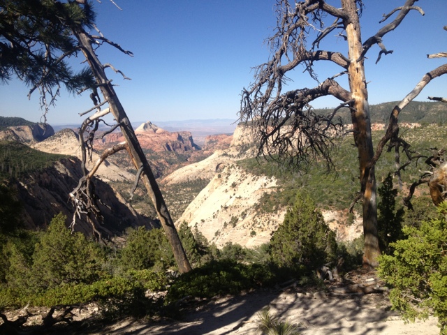
Today was our last day in Bryce Canyon before we start our two night backpack.  For our last day-hike in the park, we actually chose a hike that wasn't in the park.  About fifteen miles north and west of the park entrance is a small recreation area in the Dixie National Forest, the Red Canyon.  This relatively small area tucked away to the West of Bryce Canyon receives limited use.  The terrain is defined, as the name gives away, by bright red rock on almost every surface.  

Most visitors to the Red Rock Canyon only drive through, or maybe stop to snap a few photos as they pass through on Highway 89.  The road, accompanied by a paved bike path, winds through the lowest part of the canyon for a few miles.  In places, the road passes through some sandstone arches, making for neat photo opportunities.  

Driving west through the canyon, the trailhead was directly off the highway on the north side.  We arrived in the late morning and found only a truck with a horse trailer parked in the lot.  We would pass the party on horseback a few minutes into our hike, and then have the trail to ourselves most of the day.  

Heading north from the parking lot, the trail climbed ever so gradually through an open rocky terrain.  The path followed a large wash, crossing the dried-up river several times as it ascended towards a mesa.  Large ponderosa pine trees dotted the landscape as we picked our way through the rocky terrain and frequent horse droppings.  The area had a surprising feel of wilderness and solitude to it, considering we were only a few minutes from a busy highway.  

One mile north of the trailhead we encountered our first trail junction with the Rich Trail, but following the advice of the hiking guide I was using, we continued north on the Cassidy Trail.  Past the junction we began to climb more steeply, and gradually views began to open up around us.  Red Rocks dotted with ponderosa and limber pines starkly contrasted with brilliant blue skies overhead.  It was a remarkable landscape to be hiking through.

At the second junction with the Rich Trail, we turned south, dropping into a saddle between two red rock ridges.  Leaving the saddle, the trail climbed steeply to the top of a mesa.  From here we had an easy stroll on flat terrain towards the edge of the mesa.  As we approached the edge we were rewarded with spectacular views in every direction.  To the West we saw open grassland with a few patches of forest.  In the three other directions was a picturesque landscape of red rock mesas and ridges, crossed by rocky washes of dried out stream beds and dotted with lonely pine trees.  It was easy to picture a scene from a western movie being filmed in this setting.

We at our lunch high on the ridge, enjoying the pleasant breezes and tremendous scenery.  On the return hike, we followed the Rich Trail all the way back to the first junction of the day.  The trail descended rapidly, following a steep wash for a portion.  The footing was tricky in places and slowed our progress.  

Once we reached the junction with the Cassidy Trail we had an easy one mile downhill stroll back to the trailhead.  Three mountain bikers passed us on our way out, huffing and puffing loudly as they made the uphill climb.   These were the first people we had seen since the horse party at the start of our hike.  The solitude was a welcome relief from the crowds at Bryce Canyon this week.  

Today's hike was a pleasant one and worth the short drive out of the park.  Eric Molvar and Tamara Martin did an excellent job recommending this hike in their guide to the region "Hiking Zion and Bryce Canyon National Parks."  This book was an indispensable resource for me in planning  our time in these two southwestern Utah parks.

An aside not related to today's hike:  we were fortunate enough to attend last night's astronomy program provided by the park service and its many tremendous volunteers.  The presentation was fascinating and informative, and the night-sky watch held at the visitor center afterwards was astounding.  We had the opportunity to see a distant nebula formed by a dying star through a high-powered telescope, something I had only previously seen in pictures publicized from the Hubbell Telescope.  Another scope was fixed on Saturn.  We were able to clearly make out the rings of Saturn, and, more impressively to me, a bright red dot that was one of Saturn's moons, Titan.  Titan was something I remember reading about as a kid, when the Cassini spacecraft was being prepared for a mission to explore the distant satellite.  Bryce Canon's astronomy programs are fantastic.  I am great-full to the park and its many volunteers for this awesome opportunity.


Thursday, June 20, 2013

Bryce Canyon Day 3: Fairyland Loop Trail

Last night was the coldest night we've had during our trip so far.  I found myself burrowing into my sleeping bag in the middle of the night in an attempt to escape the cold air invading the tent.  A ranger later said that it went down into the thirties during the night.  The crisp, night air made for welcome sleeping conditions and allowed us to sleep in for the first time on our trip.  

When it was finally warm enough to coax us out of the tent we fixed some hot coffee and eggs for breakfast while packing our day-packs for our hike.  Today's destination was the Fairyland Loop Trail, near the park entrance in the north.  

This 8 mile loop trail starts from Fairyland Point, located a couple miles down a side road near the park entrance.  Many visitors miss this trail, as it is kind of "tucked away" between the park entrance and the visitor center.  The rest of the hikes are located further south of the campground, in the opposite direction.

We arrived at the parking area to find only a scattering of other cars parked and a few folks taking in the view from the overlook.  The vista from the point looked down into the Fairyland Amphitheater, packed with a dizzying variety of Hoodoos.  We elected to tackle the trail in a clockwise direction, and headed off down the trail.

The route followed a high ridge for a while, affording views to both the North and the South.  For most of the day, the trail carved through a hard red rock surface.  It provided for more stable footing than the Peekaboo Loop Trail did.  

Scatterings of Ponderosa and Limber Pines provided occasional shade without obstructing the views much.  The trail dropped gradually down to the floor of the amphitheater.  Pink cliffs and towering spires of rock surrounded us in all directions.  Much like in other sections of the park, the hoodoos were often arranged to resemble castles and other structures.  

As we wound our way around the loop, the path would climb 50-100 feet at a time, arriving at a sort of low pass.  The wind would often howell across these narrow spits of land while we paused for pictures.  The views gradually opened up more to the East as we went.  The view was of distant mesas, cliffs and mountains stretching to the horizon.  

As we hiked we traversed around Boat Mesa, acquiring views of this prominent rock from many angles.  Boat Mesa is a large rock structure that resembles a sinking ship.  A few years ago, a portion of it collapsed in a major rockslide.  Some hikers managed to snap a photo of it as the dust cloud cleared - a photo the park service has included in some of its evening programs.  it is more striking evidence of the power of the natural forces that shape this strange terrain.

About two hours into our hike we reached the junction with a side trail to views of Tower Bridge - a carved out rock that looks a bridge with towers on either side of it.  After checking out the 200 yard side trail we stopped for lunch in the shade of a towering Ponderosa Pine Tree.  

After lunch, the trail climbed steadily for close to an hour.  It wasn't exceedingly steep, but the trail was relentless in ascending up from the floor of the amphitheater.  More strange rock formations passed by on the left while we climbed.  Eventually, we arrived at Sunset Point, another jumping off spot for this loop hike.

From there the trail turned north and climbed a few forested dunes.  The views to our right gradually became more and more dramatic as we hiked.  For the first time during our trip to the park we had views to the North of the park.  Distant, forested rock formations could be seen on the horizon.  Before the trail made its return approach to Fairyland Point we passed through beautiful open meadows high above the Fairyland Amphitheater.  During this last section of our hike we were treated to a fly-over from a beautiful Red-Tailed Hawk.  I also spotted a Mountain Chickadee, a Western relative of one of my favorite backyard birds.  Much like the little black and white birds back home, he hopped from branch to branch on a bush near the trail and made no effort to move out of our path.  Chickadees are well-known as some of the bravest little birds.

The trail made another brief climb as we returned to the trailhead parking area.  It was a long 8 mile day, and it felt like we were going up hill more than we were descending, but the views were outstanding throughout our hike.  This is a vast and remarkable landscape, and one that defies easy description!


Wednesday, June 19, 2013

Bryce Canyon Day 2: Under the Rim Trail - Ponderosa Canyon to Rainbow Point

The Under the Rim trail in Bryce Canyon National Park is considered the park's premier backpacking route.  Many of the sources I had consulted for planning purposes said that our trip would not be complete without backpacking the 22.9 miles from the park's Southern end at Rainbow Point up to Bryce Point. 

 Shortly after arriving at Bryce we stopped into the visitor center to ask some preliminary questions about this backpacking route we were planning on tackling later in the week.  Ranger Geoff filled us in on some important details.  Several of the backcountry campsites near Bryce Point had been closed due to troubles with black bears in the area.  The result being that an 11 mile day was needed to finish the trail from the last available campsite up to Bryce Point.  He also let us know that a section of the trail had been wiped out by rockslides, and that finding the route could prove tricky in this area.  Water was only sporadically available on the trail, as well.  

I asked him if I should plan to get in line early to get a permit the day before our hike, as I did in Zion, and he replied "oh, no, you shouldn't have any trouble getting a permit.  Zion is a WAY better backcountry park than Bryce."  Geoff went on to tell us about a story written in Backpacker Magazine a few years ago that hailed Bryce Canyon's Under the Rim Trail as one of the best backpacking trips in America.  The park was suddenly filled with eager adventure seeking backpackers.  Geoff said that many would return to the visitor center angry with their experience afterwards.  It would seem that the Under the Rim Trail is not something we cannot live without doing.  We decided to shoot for the Riggs Spring Loop for our backpacking trip later this week instead.  The Riggs Spring Loop also leaves from Rainbow Point, but stays in the forested southern section of the park, avoiding the rock slides, and the bears.

This decision made, I wanted to see as much of the Under the Rim Trail as possible, rock-slide section aside, of course.  It turned out it would be possible to day-hike a number of sections by using the park's Rainbow Point Tour Bus, free to visitors by reservation.  We ended up arranging for a shuttle from Rainbow Point, at the Southern end of the park back to Ponderosa Canyon.  This would allow us to hike one way along the trail and end up back at our Jeep at the end of the day.  All told, this would leave us with a manageable 8 mile day.

We met the Rainbow Point Tour Bus in the parking lot at Bryce Point a little after ten in the morning.  The rest of the tourists on board were making the full round-trip guided tour of the park.  We looked a little out of place, with our hiking poles and day-packs.  The bus driver, who doubled as tour guide, included us on the tour for the rest of the passengers  "and these people, folks, are actually going to go hiking in the park today.  Make sure you watch out for those bears."  He seemed to think that Bryce's black bear population was bloodthirsty and on the loose.  We were amused by this, as we've hiked in quite a few places known for difficult ursine populations, and Bryce was not thought to be one of them!

The bus ride only took a few minutes, and then we were headed off down the Agua Canyon Connector Trail by ourselves.  "By ourselves" was a key trait of this hike.  In five hours and eight miles of hiking we saw exactly one other person.  A little before Iron Spring a man passed us jogging in the opposite direction.  I thought that one heck of a morning run!  

The solitude was charming, especially in contrast with how crowded the rest of the park had been.  The connector trail followed a high ridge with striking views to the East.  A seemingly endless collection of Hoodoos adorned the near cliffs.  Close to a mile into the hike, the connector trail began a rapid, but manageable switchback down to meet the Under the Rim Trail.  

Once on the main trail, we strolled through a lush forest of pine for hours.  The trail descended to meet the North Fork, where only a trickle of water ran.  

Shortly after this, an impressive rock formation appeared on the left side of the trail.  A collection of white rocks were clustered together on the hillside.  The structure was alone, near the top of the hill.  I thought it bore a resemblance to "weathertop" in the Fellowship of the Ring Movie.  

I couldn't resist the temptation to explore this peculiar fortress of rocks.  It was possible to walk through it in several places, and by walking around the back of it and climbing some sculpted rock, I was able to reach an overlook.  Mary took my picture here.  It felt like I was in the turret of a castle.  What a strange and unusual landscape!

We resumed our descent through the evergreen forest.  Other than the one lone jogger, we had the forest to ourselves for the day.  We stopped for lunch at the Iron Spring Campsite.  The air had warmed in the heat of the day, but a pleasant breeze blew through the canyons.

After lunch, the trail began climbing, gradually at first, and then more steeply later.  It crossed several "washes," or dried up stream beds.  Some of the washes looked almost as if a construction crew had ran a bulldozer down through the forest below the ridge. This was striking evidence of the power water during a flash flood could have on this terrain.  Thankfully, for us, there was no chance of rain in the foreseeable future. 

Crossing some of the washes required scrambling up the rocky riverbanks, and in places the trail took a moment to locate on the other side of the stream course.  As we hiked north, we also encountered more and more downed trees.  Climbing over and under these obstacles was taxing.

The last two miles of the hike were, by far, the most spectacular.  The trail climbed steadily above the various branches of the Black Birch Canyon.  As we hiked, the views to the East began to open up.  It seemed as if we could see hundreds of miles.  Mesas and ridges ran endlessly towards the horizon, and distant, larger mountains hung in the sky liked shadowy ghosts.  Many people have said that hiking in canyon country makes one feel small.  This section of the trail certainly had the feeling of being lost in a vast landscape too grand to comprehend.  

As the trail worked its way around Ponderosa Ridge it slowly turned back to the West.  We suddenly could see the observation platform built on Rainbow Point.  This provided the illusion of making us think we were close to the end of the hike, but the trail still had a few tricks up its sleeve.  As it turned North, the Under the Rim Trail skirted a ridge with stunning views to the West.  It climbed higher and higher, breaking out into a treeless world of red rock.  We had views in 360 degrees, with distant mesas and ridges to the East, a labyrinth of Hoodoos directly to the West and North, and the green ridge of Rainbow Point to the South.  If we looked more carefully to the Southwest, we could make out patches of snowfields on distant mountains.

We stopped for a few photos while crossing the exposed red rock.  The winds howled across the open terrain with enough force that we found ourselves crouching down while taking pictures.

On the other side, the trail climbed rapidly up the green ridge, ascending past the 9,100 feet mark.  The winds died down to more normal breezes in the forest.  We began to pass folks wandering down from Rainbow Point with cameras and flip flops - a sure sign that we were near the end.

This stretch of the Under the Rim Trail far exceeded my expectations.  We had solitude, dark forest, and stunning views for hours while exploring the more remote corners of Bryce Canyon National Park.  Tomorrow we are thinking we will visit one of the more heavily trafficked trails in the north part of the park in order to take in some more of the hoodoo formations up close.  After exploring the South end of Bryce today, though, we are more excited to go backpacking in this quiet, green area later in the week.  


Tuesday, June 18, 2013

Bryce Canyon National Park Day 1

We took full advantage of our first night with air conditioning and a bed in a week, sleeping in to the late, late hour of 9 AM. We had gotten used to waking with the sun, or even before it to escape the desert heat.  The BumbleBerry Inn in Springdale had a beautiful outside pool and hot tub with pleasing views of the sandstone cliffs to both the East and the West.  We lounged in the pool for a while, trying to soak up the comforts before heading back out on the road.

Once checking out of the motel, we used the first half of the day to run errands.  We had a hearty breakfast at a local joint, mailed post cards to family, purchased a few groceries for the next week, and re-stocked the cooler with ice.  Springdale, Utah is a very nice town, and very eager to cater to tourists.  The local businesses, by and large, sell just about anything one could desire, and the employees are exceedingly friendly.  

The only drawback to this little town on the doorstep of Zion was that everything was pricey.  I had never paid $16 for a single container of sunscreen before, for example!  I guess the saying is true about a captive audience.  

The road out of Zion was anything but routine.  It climbed past Canyon Junction, affording one last glimpse of Zion Canyon from a lofty perch.  Eventually the road reached a 1 mile tunnel, carved into the heart of the canyon wall.  Built by the men of the Civilian Conservation Corps during Roosevelt's New Deal, the Zion-Mt. Carmel Tunnel is an engineering marvel.  The crews built windows into the side of it, periodically, which provide the occasional glimpse of how the terrain is changing as the road travels East.  

Once emerging from the tunnel, we were treated to a strange terrain of sculpted slick-rock.  The road wound its way higher and higher up the Plateau as it went.  We stopped at a few scenic turn-outs for photos, and marveled at the cooler air.  By the time we were making the turn south for Bryce Canyon National Park, the air was a full 25 degrees cooler than on the floor of Zion Canyon.  

The road to Bryce traversed open country.  Ranch land bordered closely in most places, framed by the more distant mesas, and the even more distant mountains to the North.  We were lucky enough to drive by a field while men on horseback were herding cattle - actual cowboys!  All of this added to the "out west" motif to the area.

Entering Bryce Canyon National Park was quite different from most other parks.  Bryce is famous for the strange rock  formations called hoodoos.  Anyone who has watched a National Geographic or Travel Channel special on the American West has seen pictures of these famous and peculiar landmarks.  Driving into the park, though, provided no evidence of them.  The park road, which travels south from the entrance all the way to Rainbow Point where it dead-ends, is lined with grassy fields and gentle stands of pine trees.  No views could be seen in either direction as we drove into the park, found a campground and set up camp for the week.  

We were elated, however, with the cooler weather.  The air was little over 80 degrees, with cloudless blue skies overhead.  I was hoping we would find our tent and sleeping bag more welcoming here than we did in Zion, where we usually just sprawled naked on top of the air mattress and tried to think cool thoughts long enough to fall asleep.

With camp set up, it was time to drive around and try to gain an understanding of the landscape.  We drove to several points along the park road with views to the East.  This strange land was unlike anything I had ever seen.  The hoodoos began directly beneath the canyon rim, stretching for a couple of miles to the East in most places.  No two were the same.  They ranged from slender spires of limestone, to rock faces with windows cut out of them, to balanced rocks where the middle of the hoodoo was eroded away so severely as to create the illusion that someone had placed a boulder on top of the spire.  In many places the hoodoos were grouped together so as to resemble a structure, such as a sand castle.  

The whole scene was too strange to be real.  I couldn't resist feeling like it was some type  of optical illusion.  We drove the park road all the way to Rainbow Point.  At over 9,000 feet of elevation, this point allowed stunning views of both the hoodoo formations, and of the distant  mesas and mountains of the Grand Escalante National Staircase, stretching to the horizon in the East.  

On our drive back to camp the road was lined with, and even occasionally blocked  by, pronghorn deer.  The park is also home to elk, black bears, mountain lions and prairie dogs, to name a few species, but we have yet to see any of these.  

After cooking up some delicious stir-fry for dinner in camp, we headed to the Bryce Lodge for the evening program.  Ranger Geoff gave a surprisingly interesting presentation on the geology of the park.  I say surprising, because I have seldom found geology to be of interest.  I think its the large spans of time involved. I can understand how it took 50 million years for something to form, but it just isn't interesting to me, seeing as no one could sit around and watch it happen.  To his credit, Ranger Geoff's presentation was highly engaging and left me with a much better understanding of the processes that sculpted this bizarre landscape.  The ranger said that he taught astronomy the rest of the year, when he wasn't working at the national park.  His students are lucky to have a teacher who is so engaging and full of wonder at the natural world.

In the morning we made some breakfast and packed the day-packs for our first day hike in the park.  I was eager to explore this new terrain.  We selected the Peekaboo Loop Hike for our first ramble. A 5.5 mile hike of moderate difficulty, the Peekaboo Loop takes hikers from high on the ridge at Bryce Point down into the heart of the Hoodoos, and back out again.  We quickly learned that one downside to starting on the rim of a canyon is that you have to hike back up at the end of the day.

The trail left Bryce Point via a long and steady switch back down a moderately steep rock wall.  Pinyon, Juniper, Ponderosa and Limber Pines grew sporadically along the trail as it worked its way towards the lower elevations.  Clark's Nutcrackers, a western relative of Blue Jays, darted among the trees as we hiked.  
About half way through the descent, the trail passed through a short tunnel in the red rock.  This would be the first of several tunnels on the Peekaboo Loop Trail.

Upon reaching the bottom the actual loop portion of the hike began.  We chose to turn left and make the hike in a clockwise direction, but I think it could done either way with little difference.  The trail worked its way through the maze of hoodoos.  We would climb steeply up a wall via tightly woven switchbacks to reach a pass or tunnel and then drop back down the other side, only to repeat the process again.

The trail surface was loose rock with a coating of sand.  It was unpredictably slick, and required slow and careful food placement.  We found the 5.5 miles to be very slow going, and tiring.  

Hiking through the Hoodoos themselves was fascinating.  I felt as if I was walking through a life-size series of sand castles, or perhaps through a strange, beach themed miniature golf course.  None of it seemed real.  Occasional windows in the rock faces would provide unique photo opportunities of the more distant landscapes.  

Once completing the loop portion of the hike, we made the tiring climb back up to Bryce Point.  The weather was pleasant and mild throughout our hike, with blue skies framed by red rock formations.  

This is a bizarre place, and unlike anything I have seen before.  We are planning several more day hikes in the park, and a backpacking trip.  Hopefully by the end of the week I'll have a better grasp on this unusual landscape!  


Sunday, June 16, 2013

West Rim Backpack

The West Rim Trail in Zion National Park runs south from the Lava Point trailhead in the Northwest corner of the park.  This trail starts out at over 7,000 feet of elevation and, following the Horse Pasture Plateau, winds it way gradually towards Zion Canyon.  Upon reaching the west rim of the canyon it rapidly switchbacks through stunning side canyons all the way to the floor of Zion Canyon at the Grotto Trailhead.  This is arguably the premier backpack in Zion. We were really hoping to have the opportunity to hike the West Rim.

Taking on the West Rim entailed securing one of the limited permits issued for backcountry campgrounds in the park.  About half of the backcountry campsites in Zion are available for reservation far in advance of the intended trip.  The rest of the sites are available on a first-come first -served basis starting at 7 AM the day before the planned hike is to begin.  By visiting the Wilderness Permit Page on the Zion Webpage back home, I had determined that we had no shot of reserving a campsite in advance.  I honestly don't know who the people are that are able to plan their trips so effectively so far in advance as to nail down the exact nights and locations of their backpacking trips months before leaving home.  More power to them, I guess, but I am certainly not one of them.

That stated, our remaining choice was to shoot for a walk-in permit the day before our hike.  I set the alarm for a pre-dawn wake-up on Thursday morning.  I was in line outside the visitor center by 6:15 AM.  I had decided that forty-five minutes was the maximum amount of time I was willing to commit to waiting in the dark.  Five people were in line when I arrived there, and judging by the camp chairs and blankets, they had been there a while.  It would turn out that all of them were seeking permits to thru-hike the narrows, or enter the "subway" a super-hard slot canyon few visitors ever reach.

My gamble paid off, and by 7:30 I was out the door with permits in hand.  I was able to secure my first choice of campsites for both Friday and Saturday nights.  This would allow us to segment the 14.2 mile trail into three very short stretches.  This seemed like a really easy hike in comparison to our other wanderings, but backpacking in the desert was still a very new phenomenon to me.  I was afraid that the mid-day heat would overwhelm us, or that we would run out of water high on the plateau, or that a rattlesnake would bite or us, or - well, suffice it to say that I wanted to be cautious on our first desert backpack.  Besides, nothing wrong with having some time to kick back and relax in the hammock somewhere quiet!

We spent the rest of Thursday relaxing in the shade and preparing for our backpacking trip.  There were some exciting new details to consider with a desert trip.  It would seem that we would not need a number of items, seeing as it doesn't ever rain here.  We decided to leave behind our rain fly to our tent, our tarp, our rain gear, our pack covers, and any clothing that we weren't going to wear while hiking.  All of this was intended to balance out the added weight and space of carrying additional water.  

We usually only leave a trailhead with 6-7 liters of water for the first day of a backpack.  Finding more along the way hasn't been an issue in the East.  The map indicated the presence of a spring near our first night's campsite, but again, being nervous about the reliability of this water source I wanted to carry enough in case it wasn't flowing.  The compromise we settled on was 10 liters.  We also decided to carry the bear-canister for our food, even though bears aren't much of an issue in Zion.  Although it added weight, it would keep the squirrels and chipmunks at bay.

The last issue we needed to resolve before such an undertaking was finding a shuttle to the trailhead.  Lava Point lies about 45 minutes by car north of Springdale.  I had taken the liberty of reserving a ride on a 7 am shuttle with the Zion Adventure Company a few weeks back in the hopes that we would succeed in securing a walk-up permit.  The shuttle service wasn't cheap, but the option of doing this hike as a thru-hike was worth every penny.

My cell-phone alarm went off at 5 am Friday morning.  Neither of us had slept particularly well during the night.  A steady blast of wind came down through the canyon throughout the night, tugging at the tent stakes in all directions.  We were forced to pack up camp and finish preparing the backpacks in the pre-dawn dark while fighting with the gusty winds.  The good news was, at least it wasn't hot.

We made it to the Zion Adventure Company's parking lot with enough time left to apply sunscreen and double check the packs for last-minute additions.  The shuttle left promptly at 7 am.  A large van, either a Sprinter, or like one,  with extraordinary head room, it had room for more than ten hikers.  This particular trip took three couples to their hikes.  One couple was headed the trailhead for the Wildcat Canyon, another trail that could be linked with West Rim for a longer backpack.  The other couple, young, athletic looking folks with European accents, was headed for Lava Point as well.  They were planning to hike the West Rim as a day hike - a very long one.

The shuttle ride was worth the price alone.  John, our driver, gave us a narrative of the area's history and significance of certain locations - including his own personal cabin and the giant boulder that crashed through his fence in the middle of the night.  John said he had laid awake for several nights afterwards imagining that each sound was another rock headed for his home.  Stories like this remind me of how lucky we are in Michigan without natural disasters.  The ride also took us by a road that lead to the filming location of Butch Cassidy and the Sundance Kid.  

The road north towards the Kolab Reservoir was a wild one.  It wound through a portion of the Southwest Desert before climbing high into the desert plateau.  Gradually, the vegetation changed over to pine, and the hillsides took on a green hue.  We were all surprised to find the terrain so close to the desert to be so full of growing things. John told us that he often sees elk in this area.  Our ride was briefly interrupted by a llama, as the shaggy, white haired fella wandered into the middle of the road and just stared at us for a time.  I had the impression that we might be the only car to come this way that day.  

As we approached Lava Point, the road became rough and rutted.  John paid this no mind, flying down the sandstone-red path at alarming speeds.  Several of the bumps in the road sent us flying out of our seats.  Mary remarked that this mighty be the reason for the tremendous head room!

Eventually we reached the trailhead, and we were on our way.  The trail was surprisingly mild on our first day.  It climbed very gradually through a lush forest, interrupted occasionally by hills of bushes and cacti.  Many of the cacti had bright colored flowers opened in the direction of the sun.  The hillsides were covered in many places with a variety of other wildflowers.  I am not great at wildflower identification, but I did notice Indian Paintbrush and Honeysuckle in many places.  

The weather high on the plateau was heavenly.  The added 3,000 of elevation had the effect of lowering the temps by at least 10 degrees, and a pleasant breeze drifted through the wilderness.  Occasional views of distant mesas and canyons peaked through the vegetation.  

We arrived at campsite #7, our home for the night, before noon.  So much for a rough day!  The site had a couple of giant  pine trees on either side of it, providing for consistent shade on some part of the site at all times.  The views were somewhat limited from here, but the hill directly below us was covered in cacti - all clad in brightly colored flowers.  It was like we had our own flower garden.  

The search for water took a few minutes. We ended up locating the spring about 3 tenths of a mile from our site, down a side spur trail for campsite #6.  The spring, called Potato Hollow on the map, turned out to be a pleasant place to relax while filtering water.  Literally and oasis in the desert, it was the only source of water for miles.  Birds swarmed around the tall marshy grasses on its edges throughout the day.  The most common bird we sighted was the tree swallow - its bright green back flashing in the sun as it darted through the air and to the surface of the water.  

With plenty of water available, we spent the afternoon and early evening relaxing in our hammock, strung between two young Aspen Trees, in a thick stand of Honeysuckle.  We read books and relaxed in the shade, even tolerating the steady stream of bees that came by to visit the flowers near us.  Occasional hummingbirds zoomed by, and one looked like he was thinking about trying to feed from our hammock.  Maybe the red color confused him!

In the evening the winds picked up and the sun dropped below the hills to the west.  The air rapidly grew cold.  We fixed a boxed meal of couscous for dinner.  The chocolate bar we packed melted - covering everything in the food canister with a thin layer of chocolate.  We ended up scraping the dried-on chocolate off of many of the items as our desert.  So much for my theory that high percentage chocolate doesn't melt.  In the desert - everything melts.  Still, it was hard to complain.  We had a beautiful meadow to ourselves for the night.

We both intended to stay up late to watch the stars, but the cold night air coupled with our poor night of sleep the previous night lulled us to sleep within minutes of darkness.  During the couple of times I awoke during the night to shift sleeping positions I was treated to a blanket of stars that stretched from one horizon to the next.  The air was cold, and the world outside our tent was wonderfully quiet.  

In the morning we woke to the sun's hot rays streaming through the tent, directly onto our faces.  We prepared some grits for breakfast, with plenty of hot coffee.  I went back to the spring to filter more water.  Our campsite for Saturday night would not have any water source.  Mary packed up camp while I fetched water, and in no time we were ready to hit the trail.  Loaded down with 15 liters of water - enough for the rest of our hike, we hoped, our packs were suddenly very heavy.  

The trail threw us a bit of a curveball to start day two.  It left Potato Hollow via a steep and steady switchback up and over a green ridge.  We were both huffing and puffing within minutes.  Eventually, we did break out onto the ridge, earning views in several directions.  Looking behind us gave us a neat perspective on our campsite for the night and the surrounding area.  

The trail followed the edge of the plateau closely the rest of the day, affording remarkable views of the towering temples and deep, dark canyons on both sides of us.  More distant and prominent mountains could be seen to the West.  We passed a group of hikers - the first we had seen in 24 hours, near the junction with the Telephone Canyon Trail.  We both marveled at how none of them seemed winded, or dirty, at all.  We always feel like we are covered in filth, soaked in sweat and exhausted while backpacking.  Many of the hikers we have encountered on the trail out here must run triathlons in their spare time - they never look tired or bothered by the heat!

Passing the junction with the Telephone Canyon Trail, the West Rim Trail passed through an open scrubland that looked to have suffered through some forest fires.  The views to the west were beyond description.  Looking west from the plateau had the feeling of standing on the surface of the moon, or an alien planet perhaps.  

We were delighted when we found the post for campsite #5 near a thick stand of pine trees.  The short spur trail lead to a perfect little site - set in a stand of trees providing shade, and with views into Telephone Canyon, and across the Narrows to The Mountain of Mystery.  We set up our camp and spent the afternoon relaxing in the hammock and reading in the tent.  

In the evening, we were treated to a stunning sunset a short walk from our tent.  The sun melted, like butter, into the alien landscape of rounded gray temples, towering sandstone cliffs and distant mountains.  The whole terrain was awash in a bluish light as the sun vanished for the night.  

The air that night grew cold, and the winds raged across our narrow little spit of land.  We were wishing we had packed more clothing as we crawled into the tent for the night - but once in our down sleeping bag we slept comfortably.  

We awoke in the morning in time to watch the sunrise over the green, gentle slope of the Mountain of Mystery in the East.  After a quick breakfast we were back on the trail.  The last day promised the most spectacular scenery.  

The trail wound its way around the remainder of the Horse Pasture Plateau, providing steady views to the West and eventually South.  The dark chasm of Behunin Canyon dominated the scenery for a while.  At the junction where the Telephone Canyon Trail re-joined the West Rim Trail we began a rapid descent down the face of a sheer cliff.  The trail was only 3-5 feet across in most places, and the drop offs into the canyon were terrifying.  We picked our steps carefully as we descended the steep trail.  

Eventually, the trail arrived at a bridge across the remaining depths of a side, "hanging" canyon.  We stopped for a snack break just beyond the bridge, before beginning the climb up the other side of the canyon.  The trail switchbacked through a red sandstone world back out of the canyon, reaching a gray colored rock surface.  We were treated to a fairly level walk across open, rocky terrain for a while.  Signs installed by the park service aided in locating the trail.  It eventually resumed descending, and in no time we were arriving at Scout Lookout.  Scout Lookout is where the quiet solitude of the West Rim Trail meets to the crowded mayhem of the Angel's Landing Trail.  

Angel's Landing is the most famous day-hike in Zion.  Only a short, but steep climb up from the Grotto, it offers un-equaled views of the canyon floor.  Most of the hike, the part that reaches Scout Lookout is a hard, but safe series of tightly woven switch backs through Refrigerator Canyon.  Called Walter's Wiggles, these switchbacks make this lookout accessible to just about any hiker.  Beyond the lookout, the  half-mile trail climbs out onto a narrow mass of land jutting into the canyon.  The trail had chains bolted into the side of the rock in many places to aid in the climb.  Angel's Landing is quiet famous, partly due to the fact that six hikers have fallen to their deaths since 2004, a fact the park displays prominently on signs at the base of the climb.

I was on the fence about doing the climb, and Mary wanted no part of it.  She agreed to stay with the packs while I explored the trail.  I wasn't sure how far I would get, intimidated by the climb's reputation.  The trail climbed unpredictably, snaking around one side of a mass of rock, before switching to the other side, and then occasionally going straight up and over steep rocks, requiring climbers to hold on tight to the chains and pull themselves up to the next level.  Through all of this, the trail never ventured more than a few feet from the 1,500 foot sheer drop-off to the canyon floor.  

I was happy to find that the "cliff exposure," as the warning signs call it, wasn't as bad as I anticipated.  In most places, it's reasonably safe, as long as you don't go too fast and don't let go of the chains near the edges.  The steady stream of hikers moving in both directions might be the most challenging aspect of the climb.  Most were very responsible,though,  taking turns, and deferring to the down-hill climbers in the narrow spots.  The hike was harder from a cardiovascular perspective than I expected.  In places, the steps were quite far apart, even for my long legs.  

I reached the top in about thirty minutes. My legs were trembling from the workout and my chest heaved with exhaustion.  I stopped long enough to marvel at the view and snap a few pictures before beginning the return trip.  The down-climb was actually easier than I expected.  I elected to sit on my bottom and scoot down some of the steeper sections, while holding on to the cables for support.  In a  few minutes I was back at Scout Lookout .  I only saw one person freak out and turn around on the chains in the time I was up there. 

Reunited with Mary, I was happy to finish our backpack and seek some cold drinks and non-dehydrated food.  We made the descent through refrigerator canyon in short time, and soon were at the Grotto Trailhead waiting for a bus.  My knees are sore after a day that included more than 4,000 feet of descent on mostly hard rock surfaces, but I am delighted with the beautiful experience we were able to have in the backcountry of Zion.  

We decided to check into a motel in Springdale for the night.  We need a chance to shower, wash laundry and buy groceries for the next leg of our trip.  We had an early dinner at Pizza and Noodle - a cool local place with great pizza and air conditioning ( a must).  Tomorrow we leave for Bryce Canyon.  We have thoroughly enjoyed out time in Zion National Park, but we are looking for ward to the cooler temps in the high elevations of Bryce.