After months of deliberation, we've finally decided on our 2013 summer plans. I can't recall a winter in which we spent so many hours working on a trip, only to run into a dead end and have to start over. Issues such as permit availability, timing of snow melt and the availability of mass transit in certain parks have derailed our plans multiple times. The plan usually starts out as a grandiose trip idea, and then as I learn about the destinations, I decide that each one needs more time to be fully explored. The trips get paired down into something more manageable this way. Now that we are only three weeks away - we have settled on some destinations.
We will head out of town on June 7th and race the sunset to the west in our Jeep. We'll make the long drive to Zion National Park in Utah. After Zion, the trip will take us gradually east, allowing us to explore Bryce Canyon National Park, Canyonlands National Park, Arches National Park, Black Canyon of the Gunnison National Park and Rocky Mountain National Park. We'll do some front-country camping and day hiking in each park, along with some backpack trips in most of the parks. I'll beginning to learn about hiking and camping in a desert environment and preparing myself for the first scorpion or rattlesnake sighting!
All told, we'll spend six weeks out west, before returning home for a night. We'll head north to Sleeping Bear Dunes National Lakeshore for a week of relaxed camping on the shores of Lake Leeland with family. Next, we'll head further north, to the cold waters and quiet forests of Lake Superior Provincial Park in Ontario. The plan is to take a five day paddle trip on Lake Miji, in the park's interior.
On the drive home, we'll meet up with some more family in St. Ignace for a couple of days, including a visit to Mackinaw Island. We'll be home for a full week while I teach a high school band camp, before heading out again. Our last destination of the year will be to Vermont for the next 100 miles of the Long Trail. This section will take us from Sherburne Pass to Smuggler's Notch - arguably the most challenging and most scenic stretch of the nation's oldest thru-hike.
I'll be blogging about all of it, of course. I hope you'll follow along, as we trek from high desert mesas to dark slot canyons, across wildflower-covered meadows beneath snow-capped peaks and along calm, quiet waterways in the paths of loons and otters. All the way to the summit of Mount Mansfield in Vermont, it should be a grand adventure!
Showing posts with label Canada. Show all posts
Showing posts with label Canada. Show all posts
Friday, May 17, 2013

Wednesday, June 20, 2012
Coastal Trail: Day 1
Coastal Trail: Day 1. Monday, June 18
Today's drive went perfectly as planned, and we were heading north on Highway 17 a little after 11 AM. We even had time to fuel up at Java Joe's in Saint Ignace on the way. The always scenic drive on the Trans-Canada didn't disappoint, either. Shortly after leaving the Soo we saw a moose cow run across the highway. The Canadians have installed motion activated warning lights to alert drivers to the presence of an approaching Moose. It was neat to see them in action. It rained on and off throughout our drive which foreshadowed today's hike as well. Oddly enough, the rain stopped and the sun came out just as we reached Agawa Bay. We stepped into the camp office to purchase our backcountry permits for the week. I always take a certain amount of macho pride in informing the park rangers of our trip plans. "Look at us, we're sweet and doing something hardcore.". I figure park rangers are happy to meet people that deviate from the family of 5 in the Winebago that will spend as much time in the Tim Hortons in Wawa as they will in the woods. This particular park employee appeared to be about 19. She informed us that today was her first day on the job. She seemed less impressed by our plan to hike the Coastal Trail than I expected. Mary later surmised that we should have interpreted this lack of reciprocal excitement as a warning. Nonetheless, we changed into our hiking boots, put on sunscreen, and began to ready our packs. Predictably, the rumble of thunder began to roll in from the west, louder with each passing minute. As soon as we had finished with the usual last minute preparation routine, the skies opened up and a full force storm came crashing down on us. We set out down the trail trying to both ignore the closeness of the lightning flashes. The trail wound behind the visitor's center, which had a covered deck. Mary succeeded in convincing me to take a 10 minute break to give the weather a chance to improve. While waiting we met a man showing his friends from Indiana around the park. I couldn't help but think this must be really fabulous compared to Indiana! The man lived in the Soo, but has a place on Bachtewana Bay, south of LSPP. He told us a story of how he had helped rescue a man lost in the Bush yesterday. The man had hypothermia by the time they found him but ended up okay. This was our last interaction with others before resuming our hike and it added to the sense of foreboding. The rain lessened considerably and we set off down the trail. The weather would fluctuate from sprinkling to a full on pour for the next four hours. The first hour and a half of hiking were pleasant. The trail was wide and level and followed Lake Superior closely. Big foamy waves crashed ashore to the west. At the Agawa River the trail turned inland, joining 17 briefly to cross the river on on a large bridge. On the other side of the bridge the trail re-entered the forest. A large sign warned of steep, exposed, rocky, slippery sections of trail ahead. I would soon understand what they were referring to. Mary and I often joke about how Canadians have vastly different standards for the difficulty of wilderness travel. In canoeing a 5 foot waterfall is "a little carry over.". A week long monsoon is "just enough rain to let you know you're in Canada, eh?". The same applied to their trail ratings. A difficult trail in Michigan is considered a pleasant nature walk here. A "difficult" trail here usually entails route finding through heavy brush while using your bare hands to climb a vertical cliff. The Coastal Trail is a "very difficult " hike. The trail is marked with blue blazes placed on trees periodically. When you think you've lost the trail it is a good idea to look for a blaze to show you where it continues. Usually this involves looking left and right. Today it involved looking UP. The trail would appear to dead-end into a large pile of rocks covered in moss and interspersed with the roots of ancient pine trees. Only after careful examination would we find a notch running up and through the jumbled maze of rocks leading to a blue blaze on a tree 10 to 20 feet above our current location. Many of these short climbs required tossing the trekking poles up and over in order to have my hands free for pulling myself over these jagged edges. Sometimes we would pick our way through the mess of rocks only to find a dead-end and have to start over. It seemed that just at the point when you thought "this can not possibly be the trail " another blue blaze would appear. It would end up taking us close to three hours to cover the same distance we had hiked in the first hour of the day. Factor in the on and off rain and resulting wet rocks and it was one of the harder hikes I've ever done. Backpacking is an emotional rollercoaster most of the time. Today's hike was much harder than we expected and the rain seemed as if it might never stop. The dark and stormy weather made the terrain look even more foreign. By the time we reached the first campsite we were already in a vulnerable emotional state. The first campsite was high on a rocky bluff so we pressed on hoping the second would be better, and ideally, have water access. This would be the last campsite we could realistically expect to reach before sunset. It would not be better. It not only had water access, it had a stream running right through the tent area. This stream also had the added benefit of providing a breeding ground for the clouds of Mosquitos in the air. I think it was some Canadian's idea of a joke. We reluctantly decided to return to other campsite. I think I was one more set back away from bottoming out in the morale department. This is where backpacking is a great team sport. Mary sprang into action, setting up the tarp and tent while I climbed back down to the water to filter. The campsite ended up being much better than I thought. The rocky bluff it was on afforded 270 degree views of Lake Superior. It had enough trees well placed to allow us to put up a tarp. Mary pitched the tent on a patch of grass that appeared to be a bog. While it was dangerous to step in the wrong place and risk soaked footwear, it was also very soft for sleeping. As an added bonus, the rain stopped for good and we even had some patches of blue sky above us as we ate our dinner of red beans and rice. The end of today salvaged itself nicely. Here are some pictures from the hike and our campsite.
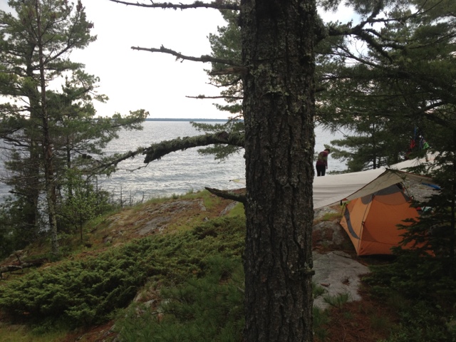


Today's drive went perfectly as planned, and we were heading north on Highway 17 a little after 11 AM. We even had time to fuel up at Java Joe's in Saint Ignace on the way. The always scenic drive on the Trans-Canada didn't disappoint, either. Shortly after leaving the Soo we saw a moose cow run across the highway. The Canadians have installed motion activated warning lights to alert drivers to the presence of an approaching Moose. It was neat to see them in action. It rained on and off throughout our drive which foreshadowed today's hike as well. Oddly enough, the rain stopped and the sun came out just as we reached Agawa Bay. We stepped into the camp office to purchase our backcountry permits for the week. I always take a certain amount of macho pride in informing the park rangers of our trip plans. "Look at us, we're sweet and doing something hardcore.". I figure park rangers are happy to meet people that deviate from the family of 5 in the Winebago that will spend as much time in the Tim Hortons in Wawa as they will in the woods. This particular park employee appeared to be about 19. She informed us that today was her first day on the job. She seemed less impressed by our plan to hike the Coastal Trail than I expected. Mary later surmised that we should have interpreted this lack of reciprocal excitement as a warning. Nonetheless, we changed into our hiking boots, put on sunscreen, and began to ready our packs. Predictably, the rumble of thunder began to roll in from the west, louder with each passing minute. As soon as we had finished with the usual last minute preparation routine, the skies opened up and a full force storm came crashing down on us. We set out down the trail trying to both ignore the closeness of the lightning flashes. The trail wound behind the visitor's center, which had a covered deck. Mary succeeded in convincing me to take a 10 minute break to give the weather a chance to improve. While waiting we met a man showing his friends from Indiana around the park. I couldn't help but think this must be really fabulous compared to Indiana! The man lived in the Soo, but has a place on Bachtewana Bay, south of LSPP. He told us a story of how he had helped rescue a man lost in the Bush yesterday. The man had hypothermia by the time they found him but ended up okay. This was our last interaction with others before resuming our hike and it added to the sense of foreboding. The rain lessened considerably and we set off down the trail. The weather would fluctuate from sprinkling to a full on pour for the next four hours. The first hour and a half of hiking were pleasant. The trail was wide and level and followed Lake Superior closely. Big foamy waves crashed ashore to the west. At the Agawa River the trail turned inland, joining 17 briefly to cross the river on on a large bridge. On the other side of the bridge the trail re-entered the forest. A large sign warned of steep, exposed, rocky, slippery sections of trail ahead. I would soon understand what they were referring to. Mary and I often joke about how Canadians have vastly different standards for the difficulty of wilderness travel. In canoeing a 5 foot waterfall is "a little carry over.". A week long monsoon is "just enough rain to let you know you're in Canada, eh?". The same applied to their trail ratings. A difficult trail in Michigan is considered a pleasant nature walk here. A "difficult" trail here usually entails route finding through heavy brush while using your bare hands to climb a vertical cliff. The Coastal Trail is a "very difficult " hike. The trail is marked with blue blazes placed on trees periodically. When you think you've lost the trail it is a good idea to look for a blaze to show you where it continues. Usually this involves looking left and right. Today it involved looking UP. The trail would appear to dead-end into a large pile of rocks covered in moss and interspersed with the roots of ancient pine trees. Only after careful examination would we find a notch running up and through the jumbled maze of rocks leading to a blue blaze on a tree 10 to 20 feet above our current location. Many of these short climbs required tossing the trekking poles up and over in order to have my hands free for pulling myself over these jagged edges. Sometimes we would pick our way through the mess of rocks only to find a dead-end and have to start over. It seemed that just at the point when you thought "this can not possibly be the trail " another blue blaze would appear. It would end up taking us close to three hours to cover the same distance we had hiked in the first hour of the day. Factor in the on and off rain and resulting wet rocks and it was one of the harder hikes I've ever done. Backpacking is an emotional rollercoaster most of the time. Today's hike was much harder than we expected and the rain seemed as if it might never stop. The dark and stormy weather made the terrain look even more foreign. By the time we reached the first campsite we were already in a vulnerable emotional state. The first campsite was high on a rocky bluff so we pressed on hoping the second would be better, and ideally, have water access. This would be the last campsite we could realistically expect to reach before sunset. It would not be better. It not only had water access, it had a stream running right through the tent area. This stream also had the added benefit of providing a breeding ground for the clouds of Mosquitos in the air. I think it was some Canadian's idea of a joke. We reluctantly decided to return to other campsite. I think I was one more set back away from bottoming out in the morale department. This is where backpacking is a great team sport. Mary sprang into action, setting up the tarp and tent while I climbed back down to the water to filter. The campsite ended up being much better than I thought. The rocky bluff it was on afforded 270 degree views of Lake Superior. It had enough trees well placed to allow us to put up a tarp. Mary pitched the tent on a patch of grass that appeared to be a bog. While it was dangerous to step in the wrong place and risk soaked footwear, it was also very soft for sleeping. As an added bonus, the rain stopped for good and we even had some patches of blue sky above us as we ate our dinner of red beans and rice. The end of today salvaged itself nicely. Here are some pictures from the hike and our campsite.
Subscribe to:
Posts (Atom)