Last night was a long, cold night of tossing and turning, although our winter bags kept us warm enough. Heavy rain pounded the tin roof of the shelter for several hours. The thru-hikers staying there were up and at it early, so we had the shelter to ourselves for breakfast. The skies cleared up a bit by the time we started hiking.
The hike started innocently enough. The trail climbed up to Ross Notch, which afforded spectacular 360 degree views. The mountains stretched endlessly in every direction, with patches of thick, white cloud drifting over the landscape. The surrounding hillsides had patchy snow lingering, but the trail was only muddy so far. After the Knob we dropped down to Camel Notch and a trail junction. We stopped for our first break here. Several AT hikers passed by while we rested. They all had dire news about what lay ahead: A raging river of liquid ice crashing right down the trail. Several of them mentioned that they were afraid they were going to lose toes in the process. One lady from New Hampshire said it was the coldest water she had ever felt. With each comment I could see Mary give me that raised-eyebrow look. Still, I wanted to press on.
The trail climbed steadily, and the further we went, the deeper the snow was we were climbing through. I think I would have preferred cold, frozen snow to the quickly melting muck we were in. It was impossible to keep our boots from getting soaked. As we approached 6,000 feet of elevation the views became truly spectacular. We had unbroken views to the East to the Mount Sterling Ridge. Mostly covered in white, it looked like something out of our ski trips to the East.
We took our lunch break before Mount Guyot. While we ate we listened to more horror stories from northbound hikers about the knee-deep ice water covering the trail ahead. All the while thick clouds of mist seemed to close in around the ridge. It was at this moment that I began to grasp the severity of our situation. We were cold and tired, sitting in deep snow, preparing to climb several hundred more feet before reaching our next shelter, which promised to be cold and snowed-in. As I finished my peanut butter wrap I realized suddenly that I was trembling from the cold. The idea of climbing higher in the suddenly chilling air was pretty unappealing. Mary was relieved to hear me suggest cutting our losses and returning the way we came.
We hiked quickly, eager for our body heat to kick in. The trail descended rapidly , and the air warmed as we walked. It seemed like just as the panic over the cold was subsiding, it began to rain. Big, hard drops of rain pelted us for the next two hours as we scurried towards Cosby Knob and a dry place to sleep. The rain aligned with the melting snow to turn the trail into a river. I've done a lot of hiking, and I don't think I've ever been so cold and miserable as I was today.
We reached the shelter and were elated to find there still was room for us. We got changed into dry clothes, had some hot soup and coffee and crawled into our sleeping bags, relieved the ordeal of the day had ended.
We're not sure what our next destination will be, but I'm certain it will avoid the cold and snowy higher elevations of the park for now. I had a coworker who once said "sometimes discretion is the better part of valor." I'm confident we made the wise choice today in getting out of the high country when we did. There is still plenty of park to explore!
Showing posts with label rain. Show all posts
Monday, April 1, 2013
Wednesday, June 20, 2012
Coastal Trail: Day 1
Coastal Trail: Day 1. Monday, June 18
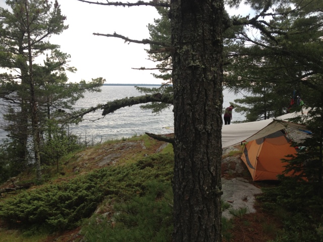
Today's drive went perfectly as planned, and we were heading north on Highway 17 a little after 11 AM. We even had time to fuel up at Java Joe's in Saint Ignace on the way. The always scenic drive on the Trans-Canada didn't disappoint, either. Shortly after leaving the Soo we saw a moose cow run across the highway. The Canadians have installed motion activated warning lights to alert drivers to the presence of an approaching Moose. It was neat to see them in action. It rained on and off throughout our drive which foreshadowed today's hike as well. Oddly enough, the rain stopped and the sun came out just as we reached Agawa Bay. We stepped into the camp office to purchase our backcountry permits for the week. I always take a certain amount of macho pride in informing the park rangers of our trip plans. "Look at us, we're sweet and doing something hardcore.". I figure park rangers are happy to meet people that deviate from the family of 5 in the Winebago that will spend as much time in the Tim Hortons in Wawa as they will in the woods. This particular park employee appeared to be about 19. She informed us that today was her first day on the job. She seemed less impressed by our plan to hike the Coastal Trail than I expected. Mary later surmised that we should have interpreted this lack of reciprocal excitement as a warning. Nonetheless, we changed into our hiking boots, put on sunscreen, and began to ready our packs. Predictably, the rumble of thunder began to roll in from the west, louder with each passing minute. As soon as we had finished with the usual last minute preparation routine, the skies opened up and a full force storm came crashing down on us. We set out down the trail trying to both ignore the closeness of the lightning flashes. The trail wound behind the visitor's center, which had a covered deck. Mary succeeded in convincing me to take a 10 minute break to give the weather a chance to improve. While waiting we met a man showing his friends from Indiana around the park. I couldn't help but think this must be really fabulous compared to Indiana! The man lived in the Soo, but has a place on Bachtewana Bay, south of LSPP. He told us a story of how he had helped rescue a man lost in the Bush yesterday. The man had hypothermia by the time they found him but ended up okay. This was our last interaction with others before resuming our hike and it added to the sense of foreboding. The rain lessened considerably and we set off down the trail. The weather would fluctuate from sprinkling to a full on pour for the next four hours. The first hour and a half of hiking were pleasant. The trail was wide and level and followed Lake Superior closely. Big foamy waves crashed ashore to the west. At the Agawa River the trail turned inland, joining 17 briefly to cross the river on on a large bridge. On the other side of the bridge the trail re-entered the forest. A large sign warned of steep, exposed, rocky, slippery sections of trail ahead. I would soon understand what they were referring to. Mary and I often joke about how Canadians have vastly different standards for the difficulty of wilderness travel. In canoeing a 5 foot waterfall is "a little carry over.". A week long monsoon is "just enough rain to let you know you're in Canada, eh?". The same applied to their trail ratings. A difficult trail in Michigan is considered a pleasant nature walk here. A "difficult" trail here usually entails route finding through heavy brush while using your bare hands to climb a vertical cliff. The Coastal Trail is a "very difficult " hike. The trail is marked with blue blazes placed on trees periodically. When you think you've lost the trail it is a good idea to look for a blaze to show you where it continues. Usually this involves looking left and right. Today it involved looking UP. The trail would appear to dead-end into a large pile of rocks covered in moss and interspersed with the roots of ancient pine trees. Only after careful examination would we find a notch running up and through the jumbled maze of rocks leading to a blue blaze on a tree 10 to 20 feet above our current location. Many of these short climbs required tossing the trekking poles up and over in order to have my hands free for pulling myself over these jagged edges. Sometimes we would pick our way through the mess of rocks only to find a dead-end and have to start over. It seemed that just at the point when you thought "this can not possibly be the trail " another blue blaze would appear. It would end up taking us close to three hours to cover the same distance we had hiked in the first hour of the day. Factor in the on and off rain and resulting wet rocks and it was one of the harder hikes I've ever done. Backpacking is an emotional rollercoaster most of the time. Today's hike was much harder than we expected and the rain seemed as if it might never stop. The dark and stormy weather made the terrain look even more foreign. By the time we reached the first campsite we were already in a vulnerable emotional state. The first campsite was high on a rocky bluff so we pressed on hoping the second would be better, and ideally, have water access. This would be the last campsite we could realistically expect to reach before sunset. It would not be better. It not only had water access, it had a stream running right through the tent area. This stream also had the added benefit of providing a breeding ground for the clouds of Mosquitos in the air. I think it was some Canadian's idea of a joke. We reluctantly decided to return to other campsite. I think I was one more set back away from bottoming out in the morale department. This is where backpacking is a great team sport. Mary sprang into action, setting up the tarp and tent while I climbed back down to the water to filter. The campsite ended up being much better than I thought. The rocky bluff it was on afforded 270 degree views of Lake Superior. It had enough trees well placed to allow us to put up a tarp. Mary pitched the tent on a patch of grass that appeared to be a bog. While it was dangerous to step in the wrong place and risk soaked footwear, it was also very soft for sleeping. As an added bonus, the rain stopped for good and we even had some patches of blue sky above us as we ate our dinner of red beans and rice. The end of today salvaged itself nicely. Here are some pictures from the hike and our campsite.
Tuesday, June 12, 2012
Driving Home
After way too many hours in the car we passed the Van Riper State Park around 7:30 and decided to call it a day. Happily there was no one camping in the entire park, being a Monday Night. Most importantly, there were no flies ruining the experience . We had the campsite about half set up when the rumble of thunder warned of coming rain. Our Kelty 16 foot tarp came in handy, covering the fire pit, picnic table and tent. As the tap-tap of light rain hit the tarp we feasted on veggie burgers, corn on the cob and foil packets of veggies and potatoes cooked in the fire. The rain was short lived and left time for some swimming in Lake Michigamme as night fell. We wrapped up the night with s'mores by the campfire as the stars came out.
Today we were up and on the road by 8 am. It has been the perfect day for driving. Last night's cold front left behind cool temps and occasional showers. It's always sad to drive south on the Mackinac Bridge, but knowing we'll be back in less than a week helps. Now we get a few days to do laundry and pack our packs for the coastal trail. Here are a couple of pictures, one of our elaborate tarp set up in the rain last night and the other of the Manistique River we drove over on the scenic route home.
Sunday, May 27, 2012
Day 2: Only in Michigan
It was a beautiful night to camp in the forest. The threat of severe weather the dark skies at sunset predicted never materialized and we both were sound asleep by 10. I almost slept through the night, waking only to the sound of a Barred Owl calling out. We woke up at 7 am to the distant rumble of thunder and a dark sky to the west. The race was on! We managed to get breakfast (oatmeal) and coffee cooked and downed before the first rain drops started falling. We finished packing as the sprinkles rapidly changed to a full-on rain.
The first two hours of hiking were spent with our heads down trudging through the streams that poured down the trails searching for the path of least resistance downhill. Midway into our hike, the rain let up and eventually stopped. Today's hike passed through some surprisingly hilly terrain. We spent most of the day climbing in and out of ravines, passing over some beautiful cascading streams. The trail would cross a tributary of the Jordan River on a footbridge and then switchback several hundred feet to provide a bird's eye view of the valley before dropping into the next ravine and starting the process over again.
Just as soon as we had pulled off the hoods on our rain jackets a second, stronger thunderstorm rolled into the valley. Time seems to move more slowly when hiking in the rain. The forest tends to look the same everywhere when the rain is pouring down and it's hard to carry on a conversation over the noise. Eventually, you realize you have no choice but to stare at your feet and keep putting one foot in front of the other. This was our mode of operation for the last hour of today's hike. By the time we climbed back up Deadman's Hill we could wring water out of our socks (and would shortly!).
Upon reaching the Jeep we peeled off our wet clothes and changed into dry ones, taking advantage of the abandoned parking lot. As we drove away in the rain in pursuit of a hot cup of coffee it was hard to imagine the sun would ever shine again. 45 minutes later we were in Traverse City and there was not a cloud to be seen! The car thermometer reads 80 degrees as we drive South. Only in Michigan! All told we logged 19 miles of hiking in two days and saw some pretty cool country for the first time. Here are some pictures:
Subscribe to:
Posts (Atom)