Coastal Trail: Day 1. Monday, June 18
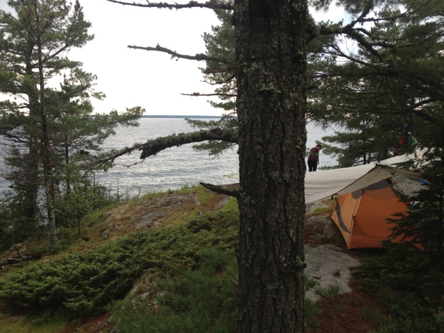
Today's drive went perfectly as planned, and we were heading north on Highway 17 a little after 11 AM. We even had time to fuel up at Java Joe's in Saint Ignace on the way. The always scenic drive on the Trans-Canada didn't disappoint, either. Shortly after leaving the Soo we saw a moose cow run across the highway. The Canadians have installed motion activated warning lights to alert drivers to the presence of an approaching Moose. It was neat to see them in action. It rained on and off throughout our drive which foreshadowed today's hike as well. Oddly enough, the rain stopped and the sun came out just as we reached Agawa Bay. We stepped into the camp office to purchase our backcountry permits for the week. I always take a certain amount of macho pride in informing the park rangers of our trip plans. "Look at us, we're sweet and doing something hardcore.". I figure park rangers are happy to meet people that deviate from the family of 5 in the Winebago that will spend as much time in the Tim Hortons in Wawa as they will in the woods. This particular park employee appeared to be about 19. She informed us that today was her first day on the job. She seemed less impressed by our plan to hike the Coastal Trail than I expected. Mary later surmised that we should have interpreted this lack of reciprocal excitement as a warning. Nonetheless, we changed into our hiking boots, put on sunscreen, and began to ready our packs. Predictably, the rumble of thunder began to roll in from the west, louder with each passing minute. As soon as we had finished with the usual last minute preparation routine, the skies opened up and a full force storm came crashing down on us. We set out down the trail trying to both ignore the closeness of the lightning flashes. The trail wound behind the visitor's center, which had a covered deck. Mary succeeded in convincing me to take a 10 minute break to give the weather a chance to improve. While waiting we met a man showing his friends from Indiana around the park. I couldn't help but think this must be really fabulous compared to Indiana! The man lived in the Soo, but has a place on Bachtewana Bay, south of LSPP. He told us a story of how he had helped rescue a man lost in the Bush yesterday. The man had hypothermia by the time they found him but ended up okay. This was our last interaction with others before resuming our hike and it added to the sense of foreboding. The rain lessened considerably and we set off down the trail. The weather would fluctuate from sprinkling to a full on pour for the next four hours. The first hour and a half of hiking were pleasant. The trail was wide and level and followed Lake Superior closely. Big foamy waves crashed ashore to the west. At the Agawa River the trail turned inland, joining 17 briefly to cross the river on on a large bridge. On the other side of the bridge the trail re-entered the forest. A large sign warned of steep, exposed, rocky, slippery sections of trail ahead. I would soon understand what they were referring to. Mary and I often joke about how Canadians have vastly different standards for the difficulty of wilderness travel. In canoeing a 5 foot waterfall is "a little carry over.". A week long monsoon is "just enough rain to let you know you're in Canada, eh?". The same applied to their trail ratings. A difficult trail in Michigan is considered a pleasant nature walk here. A "difficult" trail here usually entails route finding through heavy brush while using your bare hands to climb a vertical cliff. The Coastal Trail is a "very difficult " hike. The trail is marked with blue blazes placed on trees periodically. When you think you've lost the trail it is a good idea to look for a blaze to show you where it continues. Usually this involves looking left and right. Today it involved looking UP. The trail would appear to dead-end into a large pile of rocks covered in moss and interspersed with the roots of ancient pine trees. Only after careful examination would we find a notch running up and through the jumbled maze of rocks leading to a blue blaze on a tree 10 to 20 feet above our current location. Many of these short climbs required tossing the trekking poles up and over in order to have my hands free for pulling myself over these jagged edges. Sometimes we would pick our way through the mess of rocks only to find a dead-end and have to start over. It seemed that just at the point when you thought "this can not possibly be the trail " another blue blaze would appear. It would end up taking us close to three hours to cover the same distance we had hiked in the first hour of the day. Factor in the on and off rain and resulting wet rocks and it was one of the harder hikes I've ever done. Backpacking is an emotional rollercoaster most of the time. Today's hike was much harder than we expected and the rain seemed as if it might never stop. The dark and stormy weather made the terrain look even more foreign. By the time we reached the first campsite we were already in a vulnerable emotional state. The first campsite was high on a rocky bluff so we pressed on hoping the second would be better, and ideally, have water access. This would be the last campsite we could realistically expect to reach before sunset. It would not be better. It not only had water access, it had a stream running right through the tent area. This stream also had the added benefit of providing a breeding ground for the clouds of Mosquitos in the air. I think it was some Canadian's idea of a joke. We reluctantly decided to return to other campsite. I think I was one more set back away from bottoming out in the morale department. This is where backpacking is a great team sport. Mary sprang into action, setting up the tarp and tent while I climbed back down to the water to filter. The campsite ended up being much better than I thought. The rocky bluff it was on afforded 270 degree views of Lake Superior. It had enough trees well placed to allow us to put up a tarp. Mary pitched the tent on a patch of grass that appeared to be a bog. While it was dangerous to step in the wrong place and risk soaked footwear, it was also very soft for sleeping. As an added bonus, the rain stopped for good and we even had some patches of blue sky above us as we ate our dinner of red beans and rice. The end of today salvaged itself nicely. Here are some pictures from the hike and our campsite.
Wednesday, June 20, 2012
Sunday, June 17, 2012
Into the Woods Again
Tomorrow morning we leave for Canada and Lake Superior Provincial Park. The plan is to leave at 5 AM so we can be on the trail by 1 PM. Lake Superior Provincial Park is an amazing destination that is just far enough away from urban areas that few people ever discover it. If you are coming from the Lansing area you drive four hours to Mackinaw City, cross the Mackinac Bridge, drive another hour to Sault Ste. Marie, cross the International Bridge, pass through customs, and then drive 2 hours north on the Trans-Canada Highway to reach the southern end of the park. A passport or enhanced license is necessary for crossing the border. Travelers coming from the Canadian side, although not needing to deal with crossing the boarder, have an even farther drive from the places people actually live. Toronto, for example, is an 11 hour drive. As a result, this very large geographic area sees very few visitors. We made our first visit to LSPP in 2008. We were already planning a trip to Mackinac Island to celebrate our anniversary and had a few extra days to spend up north. I literally looked at my North American Atlas and thought, "hey this big green area north of the Soo could be cool, let's check it out." Our experience on this first visit truly summed up the unique aspects of this park. The drive north on the Trans-Canada is a spectacular one, mostly following the coastline of Lake Superior while crossing a number of wilderness rivers as they empty into the big lake. Warning signs dot the highway with the threat of rogue moose wandering into traffic. As we made the drive into the park, it was beautiful and sunny with temperatures reaching into the 80's. Reaching the Agawa Bay Campground we found a seemingly endless beach with hardy Canadian children swimming in the tumbling waves. We hurried to set up our tent, hoping to get in a swim while it was still warm. In classic Lake Superior fashion, the skies grew dark and the waves treacherous in a matter of minutes. We wound end up having to prepare our dinner that night in the car (not recommended!) because it wasn't possible to light the stove in the gale force winds. By the time the sun came back up it was forty degrees colder than the day before and Superior was a raging sea of whitewater. 8-10 foot waves crashed into the shore loudly enough to drown out conversation at the campsites. Although the air temperature would not reach the 60's again on our trip, we managed a number of day hikes, and a couple of paddles in the interior lakes. While we were in the park we saw a couple of bears, as well as beavers and otters. According to the park website, LSPP encompasses over 1,600 square kilometers of unspoiled wilderness. Included in the park are countless rivers and lakes, miles and miles of spectacular Lake Superior Coastline, towering cliffs home to Peregrine Falcons and a forest that stretches north to the beginning of the Boreal Forest. The night skies are some of the best around. After a couple of days in the park we felt as if we were a thousand miles from home. I've yet to find another destination that is within a day's drive of Lansing that has a fraction of the natural beauty of LSPP. We've since been back four more times and have hiked and paddled many of the routes through the park. This visit will be our first backcountry trip within the park, however. The coastal trail runs for 39 miles, mostly along the Lake Superior coastline, starting at Agawa Bay and ending in the Gargantua Harbor area. I won't be able to post updates while I'm in the park (it is one of the few places left with no cell service) but will post a full summary and pictures on Friday when we head home. Here are a couple of pictures from our previous trips:
Tuesday, June 12, 2012
Driving Home
After way too many hours in the car we passed the Van Riper State Park around 7:30 and decided to call it a day. Happily there was no one camping in the entire park, being a Monday Night. Most importantly, there were no flies ruining the experience . We had the campsite about half set up when the rumble of thunder warned of coming rain. Our Kelty 16 foot tarp came in handy, covering the fire pit, picnic table and tent. As the tap-tap of light rain hit the tarp we feasted on veggie burgers, corn on the cob and foil packets of veggies and potatoes cooked in the fire. The rain was short lived and left time for some swimming in Lake Michigamme as night fell. We wrapped up the night with s'mores by the campfire as the stars came out.
Today we were up and on the road by 8 am. It has been the perfect day for driving. Last night's cold front left behind cool temps and occasional showers. It's always sad to drive south on the Mackinac Bridge, but knowing we'll be back in less than a week helps. Now we get a few days to do laundry and pack our packs for the coastal trail. Here are a couple of pictures, one of our elaborate tarp set up in the rain last night and the other of the Manistique River we drove over on the scenic route home.
Monday, June 11, 2012
Driving around the UP: Day 3
I think today may be a personal best for hours spent driving around. Last night started out great with a scenic drive out H58 to the Twelvemile Campground. This is easily one of the most beautiful campgrounds you will ever stay at. It is a rustic campground set in a stand of tall pines atop large sand dunes on Lake Superior. From the good campsites you can watch the sun set into the shimmering blue waters with not a drop of land visible in any direction. We once kayaked into this campground and spent a great night of camping. As we drove into the campground we were excited to find that we had our choice of campsites on the waterfront. We would soon learn why the campground was abandoned. We jumped out of the Jeep and began pulling the camping equipment out. Before we had even set the tent up our legs were covered in black flies. The black flies that are common on the lakeshore, called stable flies, are made much worse by hot weather and an on shore breeze. We had both. Teased by the dramatic view of the setting sun over the lake we were committed to toughing it out. That is, until we tried to put the sleeping bag and air mattresses in the tent. Even a coordinated, two person effort resulted in a dozen or so flies making it into the tent. It was at this moment that we realized it would be an exercise in insanity to camp. We quickly loaded the Jeep back up and found that the flies had invaded our ride as well. The only way to escape the little terrors was to open the top and windows and drive like a crazy person down H58. By the time we drove back into Munising only a few hardy flies were still crawling around. Luckily, we found a hotel with vacancy and decent rates and were able to recover from our black fly encounter with a six pack, pizza, and the Tigers!
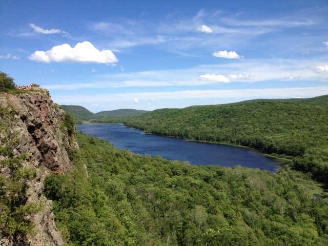
After a great breakfast at Sidney's in Munising we decided to spend our last night camping in the Porcupine Mountains. We made the three hour drive to the Western end of the UP and Union Bay campground. As the Jeep rolled to a stop at the camper registration booth the sky filled with clouds of black flies. They made a tapping sound as they smacked into the windshield, dive bombing our vehicle with abandon. Camping here wasn't going to be any better than last night. Resigned to our fate, we visited a couple of our favorite sites in the park: the falls of the Presque Isle River and the view from the escarpment of Lake of the Clouds. Both were every bit as beautiful as I remembered. I've posted some pictures below. Now we are driving east. The plan is to find a campground inland somewhere away from the worst of the flies. Even with the black flies it is still great to be in the UP.
Sunday, June 10, 2012
Driving Around the UP: Day Two
The longest day of the year, in terms of daylight, is approaching in the next 10 days. We decided to make the most of this one by setting our alarm for 5 am.
Van Riper State Park turned out to be Grand Central for campers last night. In addition to the throngs of tourists and locals enjoying the warm weather, it was "paws in the park day." The average campground had two wet, smelly and happy pooches. This made for an entertaining evening as it only takes one barking dog to start a concert. This did make me miss my cats, although camping would most definitely not be their thing!
The park is situated right on the shores of beautiful Lake Michigamme. We took advantage of the warm weather and went for a swim at sunset before enjoying a fire and the first s'mores of the season. It was a magical night in the forest, with mild temps and a blanket of stars. It was a quiet night, not the creepy too quiet kind, but just right. I slept like a rock, awakening to that 5 am alarm a bit too soon for my taste.
We threw the camp gear in the Jeep and headed for nearby Craig Lake Stare Park. Craig Lake is Michigan's most remote park (other than the island park Isle Royale). It is reached by driving 9 miles on a rough gravel road weaving through a network of swamps, bogs and woods . The entrance bears a warning sign about the road conditions, but the recent dry weather made for little difficulty this morning. We parked at the trailhead and took the day's first cup of coffee for a walk down to the shores of Craig Lake. The waters were perfectly calm, reflecting the trees and blue skies in a perfect mirror image. Craig Lake is home to a large heard of Michigan's moose population. We walked quietly along the shores hoping to spot one of the giant creatures. Moose can be elusive and we would have to settle for a beautiful sunrise.
Our marathon day continued with the drive into Marquette for breakfast at The Sweetwater Cafe. This was our first trip to this place that specializes in multicultural, organic food prepared with local ingredients . The Huevos Rancheros was some of the best I have ever had, served with black beans, rice and homemade salsa. After an extra cup of coffee we were back on the road. This time we headed north to the town of Big Bay and a rustic hike to a famous series of waterfalls. The Yellow Dog River runs through the Ottawa National Forest and the McCormick National Wilderness, named for the family that donated the land to the government for recreational use by all. The trail head lies twenty miles west of Big Bay and is only reached after navigating a maze of dirt roads and two-tracks. Driving to a remote trail in the woods is often a nerve racking experience, and this time certainly was. The "roads" were unmarked, meaning we had to use the compass and trip odometer to figure out which intersection we were at and the correct way to turn. The farther we drove the more remote it got and the louder the voice sounded in the back of mind telling me to turn around. It is impossible at moments like these not to play-out the worse case scenario game. "What if we get lost?". "What if the Jeep breaks down?". "What if the folks we just drove by in that militia style compound are in fact armed to the teeth and harbor a deep-seated resentment of city folk in red Jeeps?". Fortunately, none of these played out and after a 45 minute bumpy drive, we found ourselves at an abandoned trail head in the middle of an old growth forest. It was a four mile hike round trip out to the Yellow Dog River. Once we reached the river we picked our way along a faint trail that reinforced the remoteness of this area. Staying on the trail required climbing under and over downed trees, rock hopping through quick-sand like mud and eventually shimmying across the river on a well-placed downed tree. The reward was a fantastic view of the 15 foot cascade that few people ever get to see. After enjoying the view for as long as the black flies would allow, we made the return hike to the Jeep. The car thermometer read 95 and we were both hot, sweaty and buggy from our hike. It was the perfect time for a swim. We drove back to Big Bay, paid the two dollar visitor fee at the Marquette County Park and jumped into the refreshing waters of Independence Lake. There is nothing better than swimming in cold clear water on a hot day.
Now we are on our way to Pictured Rocks National Lakeshore and Twelvemile Campground. Thanks to our early start, we still have close to 5 hours of daylight left! Here are some pictures:
.
Van Riper State Park turned out to be Grand Central for campers last night. In addition to the throngs of tourists and locals enjoying the warm weather, it was "paws in the park day." The average campground had two wet, smelly and happy pooches. This made for an entertaining evening as it only takes one barking dog to start a concert. This did make me miss my cats, although camping would most definitely not be their thing!
The park is situated right on the shores of beautiful Lake Michigamme. We took advantage of the warm weather and went for a swim at sunset before enjoying a fire and the first s'mores of the season. It was a magical night in the forest, with mild temps and a blanket of stars. It was a quiet night, not the creepy too quiet kind, but just right. I slept like a rock, awakening to that 5 am alarm a bit too soon for my taste.
We threw the camp gear in the Jeep and headed for nearby Craig Lake Stare Park. Craig Lake is Michigan's most remote park (other than the island park Isle Royale). It is reached by driving 9 miles on a rough gravel road weaving through a network of swamps, bogs and woods . The entrance bears a warning sign about the road conditions, but the recent dry weather made for little difficulty this morning. We parked at the trailhead and took the day's first cup of coffee for a walk down to the shores of Craig Lake. The waters were perfectly calm, reflecting the trees and blue skies in a perfect mirror image. Craig Lake is home to a large heard of Michigan's moose population. We walked quietly along the shores hoping to spot one of the giant creatures. Moose can be elusive and we would have to settle for a beautiful sunrise.
Our marathon day continued with the drive into Marquette for breakfast at The Sweetwater Cafe. This was our first trip to this place that specializes in multicultural, organic food prepared with local ingredients . The Huevos Rancheros was some of the best I have ever had, served with black beans, rice and homemade salsa. After an extra cup of coffee we were back on the road. This time we headed north to the town of Big Bay and a rustic hike to a famous series of waterfalls. The Yellow Dog River runs through the Ottawa National Forest and the McCormick National Wilderness, named for the family that donated the land to the government for recreational use by all. The trail head lies twenty miles west of Big Bay and is only reached after navigating a maze of dirt roads and two-tracks. Driving to a remote trail in the woods is often a nerve racking experience, and this time certainly was. The "roads" were unmarked, meaning we had to use the compass and trip odometer to figure out which intersection we were at and the correct way to turn. The farther we drove the more remote it got and the louder the voice sounded in the back of mind telling me to turn around. It is impossible at moments like these not to play-out the worse case scenario game. "What if we get lost?". "What if the Jeep breaks down?". "What if the folks we just drove by in that militia style compound are in fact armed to the teeth and harbor a deep-seated resentment of city folk in red Jeeps?". Fortunately, none of these played out and after a 45 minute bumpy drive, we found ourselves at an abandoned trail head in the middle of an old growth forest. It was a four mile hike round trip out to the Yellow Dog River. Once we reached the river we picked our way along a faint trail that reinforced the remoteness of this area. Staying on the trail required climbing under and over downed trees, rock hopping through quick-sand like mud and eventually shimmying across the river on a well-placed downed tree. The reward was a fantastic view of the 15 foot cascade that few people ever get to see. After enjoying the view for as long as the black flies would allow, we made the return hike to the Jeep. The car thermometer read 95 and we were both hot, sweaty and buggy from our hike. It was the perfect time for a swim. We drove back to Big Bay, paid the two dollar visitor fee at the Marquette County Park and jumped into the refreshing waters of Independence Lake. There is nothing better than swimming in cold clear water on a hot day.
Now we are on our way to Pictured Rocks National Lakeshore and Twelvemile Campground. Thanks to our early start, we still have close to 5 hours of daylight left! Here are some pictures:
.
Saturday, June 9, 2012
Driving around the UP day 1
I started today with a jog along the Lake Huron waterfront. Last night's storms had moved on and it was a pleasant morning near the water. There was a thin veil of fog hanging over Mackinaw Island. The water was glassy smooth except for the ripples given off by a couple of loons enjoying the last calm days before the mass of tourists begin arriving for the summer. If my daily run could always be along a scene like this I think I could be a great runner!
After checking out of our hotel we headed to Java Joe's Cafe for breakfast. Joe's is a small joint set in the parking lot of the Holiday Inn Express. The place is built with a hippie theme complete with Jimmy Buffet concerts playing on a loop on a small tv at the entrance. There is indoor and outdoor seating and many of the tables have a view of the water. Most days Joe himself will wait on you. Today's fare included breakfast burritos and nutella crepes (which I highly recommend). Joe worked the room, giving tourists directions to the best attractions in the area.
After filling up at breakfast we hit the road, heading west on US 2. It turned into a gorgeous day with temps climbing into the 80s as we sped past the north shore of lake Michigan. US 2 heading west out of st ignace is one of the most scenic drives in Michigan. There are numerous spots to pull off and swim, and a mix of sand dunes and thick pine forests line the opposite side of the road.
At Blaney Park we headed north on M77 and made a quick visit to the Seney National Wildlife Refuge. Seney is a true gem, one that most people drive past without visiting. When the area was clearcut by logging in the past it created a strange terrain. Wildlife experts flooded the area and built a series of damns, bridges and weirs to create a manageable system of wetlands. The refuge is part of the flyway that many migratory birds use to reach their summer grounds in the artic. In addition to a wide range of birds, Seney is home to moose, bear, wolves and many other mammals. On one visit we saw an otter swimming in one if the pools. The refuge is huge, and most of it is off limits to visitors to ensure successful nesting seasons for birds. There is, however, a 7 mile loop road that allows visitors to drive through part of the refuge. On our drive through this time we were treated to several loons, an osprey and bald eagle battling in mid air and too many swans to count. Seney is always worth the stop.
Tonight we're headed farther west to check out Van Riper State Park. This will be our first visit to this park. We're excited to see what this part of the UP has to offer. That's all for now. Life is good in the UP!
After checking out of our hotel we headed to Java Joe's Cafe for breakfast. Joe's is a small joint set in the parking lot of the Holiday Inn Express. The place is built with a hippie theme complete with Jimmy Buffet concerts playing on a loop on a small tv at the entrance. There is indoor and outdoor seating and many of the tables have a view of the water. Most days Joe himself will wait on you. Today's fare included breakfast burritos and nutella crepes (which I highly recommend). Joe worked the room, giving tourists directions to the best attractions in the area.
After filling up at breakfast we hit the road, heading west on US 2. It turned into a gorgeous day with temps climbing into the 80s as we sped past the north shore of lake Michigan. US 2 heading west out of st ignace is one of the most scenic drives in Michigan. There are numerous spots to pull off and swim, and a mix of sand dunes and thick pine forests line the opposite side of the road.
At Blaney Park we headed north on M77 and made a quick visit to the Seney National Wildlife Refuge. Seney is a true gem, one that most people drive past without visiting. When the area was clearcut by logging in the past it created a strange terrain. Wildlife experts flooded the area and built a series of damns, bridges and weirs to create a manageable system of wetlands. The refuge is part of the flyway that many migratory birds use to reach their summer grounds in the artic. In addition to a wide range of birds, Seney is home to moose, bear, wolves and many other mammals. On one visit we saw an otter swimming in one if the pools. The refuge is huge, and most of it is off limits to visitors to ensure successful nesting seasons for birds. There is, however, a 7 mile loop road that allows visitors to drive through part of the refuge. On our drive through this time we were treated to several loons, an osprey and bald eagle battling in mid air and too many swans to count. Seney is always worth the stop.
Tonight we're headed farther west to check out Van Riper State Park. This will be our first visit to this park. We're excited to see what this part of the UP has to offer. That's all for now. Life is good in the UP!
Friday, June 8, 2012
Going up north
Today is a holiday in the Moose household (and probably in the homes of many teachers). Today was the last day of school. Sure, there will be work obligations, but in the next 88 days I will not be responsible for teaching children, will not have to put on a tie, and will be free to pursue my outdoors pursuits wholeheartedly.
We celebrated our liberation by packing the jeep and heading north. This time to Michigan's upper peninsula. We'll stay tonight at the Driftwood Inn and Bar and then head further north and west for some camping and hiking.
Driving north on 127 and I 75 is a part of the Michigan culture. These highways are our escape route from the monotony of civilized life to the town, lakes, rivers and forests that blanket most of our state. The mass of people are trapped in and near the major cities comprising a small land area. The rest of the state is sparsely populated and home to what my wife affectionately refers to as "the pretty."
Close to 7 pm we made the trip across the Mackinac Bridge. Crossing the bridge is another Michigan tradition. I'm always amazed at the number of people that live in Michigan or visit our state that never see the Mackinac Bridge and make the crossing to the the wilds of the UP (upper peninsula). We drove across the bridge as we usually do, mouth agape, speechless, staring at the endless water to the west and the island shrouded in mist to the east. The water on the Lake Michigan side is a brilliant shade of blue. The water to the east an enchanting emerald green. Looking to the west it is possible to imagine the water reaching the sky itself. We couldn't be happier to be back up north.
We celebrated our liberation by packing the jeep and heading north. This time to Michigan's upper peninsula. We'll stay tonight at the Driftwood Inn and Bar and then head further north and west for some camping and hiking.
Driving north on 127 and I 75 is a part of the Michigan culture. These highways are our escape route from the monotony of civilized life to the town, lakes, rivers and forests that blanket most of our state. The mass of people are trapped in and near the major cities comprising a small land area. The rest of the state is sparsely populated and home to what my wife affectionately refers to as "the pretty."
Close to 7 pm we made the trip across the Mackinac Bridge. Crossing the bridge is another Michigan tradition. I'm always amazed at the number of people that live in Michigan or visit our state that never see the Mackinac Bridge and make the crossing to the the wilds of the UP (upper peninsula). We drove across the bridge as we usually do, mouth agape, speechless, staring at the endless water to the west and the island shrouded in mist to the east. The water on the Lake Michigan side is a brilliant shade of blue. The water to the east an enchanting emerald green. Looking to the west it is possible to imagine the water reaching the sky itself. We couldn't be happier to be back up north.
Subscribe to:
Posts (Atom)