The alarm went off at 5 am and after a couple of necessary snoozes we were on the road. We made a quick stop at Big Apple Bagel for coffee and bagels and started the long trek east. Going out east is a much different experience than the usual trip up north. Going up north in Michigan involves passing through mostly undeveloped woodlands dotted with small communities like Grayling, Gaylord and Mackinaw City. Driving east entails passing through endless suburban sprawl marred only by delightful cities such as Flint, Port Huron, Sarnia and Hamilton. On these marathon days I reach a point at which I begin to think "why on earth are we doing this? I think we might pass away in the car!". All of the exits have the same five businesses and the local radio stations all play the same Katy Perry song with maddening regularity
The border crossing can also be a real treat. I have nothing but respect for the men and women who guard our borders and keep us safe. I'm sure it is an impossibly difficult job. After many hours in the car, however it can be tiresome to discuss the origin of the contraband carrots in my cooler. You know, the ones I bought at Kroger in Holt. At today's crossing south of Niagara Falls, NY we had just slowed to a stop at the border crossing when I decided to open my door for a second to stretch my legs. A gust of wind caught hold of the pile of papers I had on my lap and scattered them into the road. I was forced to sprawl onto the pavement and use my arms and legs to knock down and secure the wayward papers, all the while wondering if I had caught the eye of a customs officer deciding which car to search. At times like these Mary likes to break into song. You never know when a nice rendition of Lee Greenwood could come in handy. Fortunately, the customs officer only asked us a couple of questions and we were back on the road again.
Passing into New York things started to improve. Roadside service plazas offered Starbucks frequently enough to keep us dangerously caffeinated. After we made a lunch stop in Rochester the thru-way began to pass through some National Wildlife Refuges. A bald eagle flew directly over the Jeep at one point. The flat terrain of Ontario slowly evolved into hills that grew larger as we drove.
As we entered Massachusetts the Berkshire Mountains began to dominate the landscape. The mountains were veiled in wispy patches of fog drifting across the dark green masses of land. The skies had grown gray and occasional rain showers began as we drove into Williamstown. This area is still one of mystery to us. It gets dark much earlier in the east, which definitely adds to the sense of the unknown. We checked into our hotel and found some dinner at a great tapas place. Tomorrow we pick up the rental car and shuttle the Jeep to the north end of the trail. We made the last few painful decisions of what to take and what to leave in the Jeep before bed. I'm doubting we'll sleep very well tonight as we're both pretty hyped up to begin our hike. Here is the view entering Massachusetts:
Tuesday, June 26, 2012
Sunday, June 24, 2012
Last Few Hours of Home
Tomorrow will be our last day in Michigan until sometime in August. It is a strange sensation to look around my house and know that I won’t see the same familiar furniture, wall hangings, pictures or black cats for a while. I’ve spent parts of the past couple of days busying myself with last minute tasks for our trip while trying to squeeze the last amounts of home out of this place at the same time. On our drive home from Canada we made a list of the foods we thought we would miss the most on the trail. We visited Horrock’s, a farm market in Lansing and filled a cart with fresh vegetables, fruit, bakery bread and other perishable foods that we will soon have to do without. Mary and I both spend time with family members we are going to miss while we are hiking. We visited Moosejaw in East Lansing for new trekking poles, a back up water filter cartridge and some new wool socks. I figure if I’m hiking 273 miles I am likely to wear out old socks before reaching the Canadian border. I applied water proof to our hiking boots and insect repellant to all of our hiking clothes. Our mail drops are boxed up and ready to go. The house is cleaned, the laundry is all done, the bills are paid and our packs are stuffed and loaded in the Jeep. I feel a bit like Frodo leaving the shire, but at least I’ve had more time to pack. In less than 48 hours we’ll be in Vermont and the adventure will really begin.
Friday, June 22, 2012
Coastal Trail: Day Three
Our campsite last night turned out to be really cool. There were a number of large slabs of rock that lead out to Lake Superior behind the campsite. With a bit of careful scrambling we were able to climb all the way out onto a giant flat rock with spectacular views. To the north was Agawa Point. To the east was a quiet little cove lined with a rock beach. To the west a number of small islands home to lonely pine trees blocking out the setting sun. To the south we could see all the way to Montreal River Harbor in the distance. From this vantage point we watched two otters swim by while eating our dinner. Bald eagles passed overhead multiple times and the call of loons was heard frequently. Unfortunately, this was not the only wildlife that showed up. Sometime during the early evening it appeared that all of the mosquitoes in the north woods must have hatched. By the time we were done with dinner they were massing in small clouds around our heads. We hung the bear bag from a high branch on a giant pine tree over the water and retreated to our tent. Getting into the tent before sunset is never a great idea. It's hard enough to sleep on the ground in the confined space of a backpacking tent overnight. It's another to spend 12 hours in the tent. It ended up being a long night of tossing and turning. In the morning our insect assailants gained allies. Both black flies and deer flies arrived with the sun. Putting away the tent and packing became a one-handed activity, freeing your other hand to defend yourself. By the time we were on the trail both of us had more bug bites than we could count. Add in the fact that the heat had climbed into the 80's and we had a tough day of hiking ahead of us. Many of the climbs we had done on the way out were even harder to down climb. On some I found the best strategy to be throwing my pack and poles to the bottom and then climbing backwards down the ledge using both of my hands. In the hot heat of midday this level of exertion was draining. We took lunch on a rock beach in the bright sun. An eagle passed overhead as we ate our nutella wraps, salted almonds and dried apricots. Shortly after hiking away from the shore we both ran out of water. We decided, in light of the heat and the swarms of biting insects, to do a long day and finish today. The next couple of hours were painfully hard in the oppressive heat with no water. I was overjoyed to finally see the roof of the Visitor's Center through the tree tops. We drove the Jeep down to the camp bathrooms for showers and a chance to refill our water bottles. Now that we are both clean and dry we are driving south on the Trans-Canada heading back to Michigan. The plan is to get a room in Saint Ignace for the night so we don't have to drive home at 2 am. Our first experience on the Coastal Trail was full of beautiful scenery and solitude, but hard. I have hiked out east, out west in the Rocky Mountains and in the south and have never been on a trail as difficult as this. I can see now why the park brochure says "allow 7 to 14 days for a one way through hike". I would still recommend LSPP for a visit but not necessarily the Coastal Trail (unless you like to live like Bear Gryls!). Here are some pictures:
Thursday, June 21, 2012
Coastal Trail Day 2
Last night was a pleasant night for sleeping. The forest was quiet and the weather calm. We were treated to a bit of a light show, as some pretty intense looking storms passed over the Montreal River Harbor to the south. Happily, the storms stayed to the south all night. In the morning we emerged from the tent just in time to watch three bald eagles (one adult, two immature) fly over the campsite. We had oatmeal and coffee while we discussed the plans for the day. Although we considered heading back south or staying put at this campsite due to the unexpected difficulty of the trail, we settled on hiking farther north to see if the trail improved. The forest (and our gear) had dried out during the night and the surfaces we were hiking on seemed more reliable now. The trail however, would only get harder. At one point it climbed steely enough that it was necessary to place my knee on the step before using my hands to drag the rest of my body into a kneeling position at the top. Some of these climbs required a two person effort to get Mary over them. Next the "trail" emptied out onto a field of boulders on the beach. For the next couple hundred yards we would need to walk precariously across the rock beach. We soon came to another camp site, this one right on the lake. We had another conversation about staying or continuing on. Mary observed that the map showed the trail crossing twenty topo lines before the next camp site. So far we had passed four. They are twenty meter lines. Although we are disappointed to not make it further north on this trip, we don't want to risk an injury with the Long Trail a week away. We'll start hiking south tomorrow and finish Thursday or Friday depending in the weather and how fast we hike. We enjoyed a brief and very cold swim at the campsite this afternoon and will probably get to use our hammock if the weather continues to cooperate. Here are some pictures.
Wednesday, June 20, 2012
Coastal Trail: Day 1
Coastal Trail: Day 1. Monday, June 18
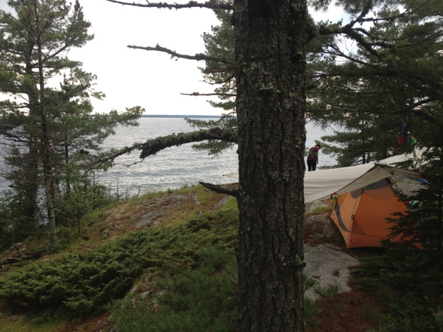
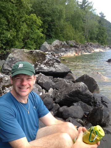
Today's drive went perfectly as planned, and we were heading north on Highway 17 a little after 11 AM. We even had time to fuel up at Java Joe's in Saint Ignace on the way. The always scenic drive on the Trans-Canada didn't disappoint, either. Shortly after leaving the Soo we saw a moose cow run across the highway. The Canadians have installed motion activated warning lights to alert drivers to the presence of an approaching Moose. It was neat to see them in action. It rained on and off throughout our drive which foreshadowed today's hike as well. Oddly enough, the rain stopped and the sun came out just as we reached Agawa Bay. We stepped into the camp office to purchase our backcountry permits for the week. I always take a certain amount of macho pride in informing the park rangers of our trip plans. "Look at us, we're sweet and doing something hardcore.". I figure park rangers are happy to meet people that deviate from the family of 5 in the Winebago that will spend as much time in the Tim Hortons in Wawa as they will in the woods. This particular park employee appeared to be about 19. She informed us that today was her first day on the job. She seemed less impressed by our plan to hike the Coastal Trail than I expected. Mary later surmised that we should have interpreted this lack of reciprocal excitement as a warning. Nonetheless, we changed into our hiking boots, put on sunscreen, and began to ready our packs. Predictably, the rumble of thunder began to roll in from the west, louder with each passing minute. As soon as we had finished with the usual last minute preparation routine, the skies opened up and a full force storm came crashing down on us. We set out down the trail trying to both ignore the closeness of the lightning flashes. The trail wound behind the visitor's center, which had a covered deck. Mary succeeded in convincing me to take a 10 minute break to give the weather a chance to improve. While waiting we met a man showing his friends from Indiana around the park. I couldn't help but think this must be really fabulous compared to Indiana! The man lived in the Soo, but has a place on Bachtewana Bay, south of LSPP. He told us a story of how he had helped rescue a man lost in the Bush yesterday. The man had hypothermia by the time they found him but ended up okay. This was our last interaction with others before resuming our hike and it added to the sense of foreboding. The rain lessened considerably and we set off down the trail. The weather would fluctuate from sprinkling to a full on pour for the next four hours. The first hour and a half of hiking were pleasant. The trail was wide and level and followed Lake Superior closely. Big foamy waves crashed ashore to the west. At the Agawa River the trail turned inland, joining 17 briefly to cross the river on on a large bridge. On the other side of the bridge the trail re-entered the forest. A large sign warned of steep, exposed, rocky, slippery sections of trail ahead. I would soon understand what they were referring to. Mary and I often joke about how Canadians have vastly different standards for the difficulty of wilderness travel. In canoeing a 5 foot waterfall is "a little carry over.". A week long monsoon is "just enough rain to let you know you're in Canada, eh?". The same applied to their trail ratings. A difficult trail in Michigan is considered a pleasant nature walk here. A "difficult" trail here usually entails route finding through heavy brush while using your bare hands to climb a vertical cliff. The Coastal Trail is a "very difficult " hike. The trail is marked with blue blazes placed on trees periodically. When you think you've lost the trail it is a good idea to look for a blaze to show you where it continues. Usually this involves looking left and right. Today it involved looking UP. The trail would appear to dead-end into a large pile of rocks covered in moss and interspersed with the roots of ancient pine trees. Only after careful examination would we find a notch running up and through the jumbled maze of rocks leading to a blue blaze on a tree 10 to 20 feet above our current location. Many of these short climbs required tossing the trekking poles up and over in order to have my hands free for pulling myself over these jagged edges. Sometimes we would pick our way through the mess of rocks only to find a dead-end and have to start over. It seemed that just at the point when you thought "this can not possibly be the trail " another blue blaze would appear. It would end up taking us close to three hours to cover the same distance we had hiked in the first hour of the day. Factor in the on and off rain and resulting wet rocks and it was one of the harder hikes I've ever done. Backpacking is an emotional rollercoaster most of the time. Today's hike was much harder than we expected and the rain seemed as if it might never stop. The dark and stormy weather made the terrain look even more foreign. By the time we reached the first campsite we were already in a vulnerable emotional state. The first campsite was high on a rocky bluff so we pressed on hoping the second would be better, and ideally, have water access. This would be the last campsite we could realistically expect to reach before sunset. It would not be better. It not only had water access, it had a stream running right through the tent area. This stream also had the added benefit of providing a breeding ground for the clouds of Mosquitos in the air. I think it was some Canadian's idea of a joke. We reluctantly decided to return to other campsite. I think I was one more set back away from bottoming out in the morale department. This is where backpacking is a great team sport. Mary sprang into action, setting up the tarp and tent while I climbed back down to the water to filter. The campsite ended up being much better than I thought. The rocky bluff it was on afforded 270 degree views of Lake Superior. It had enough trees well placed to allow us to put up a tarp. Mary pitched the tent on a patch of grass that appeared to be a bog. While it was dangerous to step in the wrong place and risk soaked footwear, it was also very soft for sleeping. As an added bonus, the rain stopped for good and we even had some patches of blue sky above us as we ate our dinner of red beans and rice. The end of today salvaged itself nicely. Here are some pictures from the hike and our campsite.
Sunday, June 17, 2012
Into the Woods Again
Tomorrow morning we leave for Canada and Lake Superior Provincial Park. The plan is to leave at 5 AM so we can be on the trail by 1 PM. Lake Superior Provincial Park is an amazing destination that is just far enough away from urban areas that few people ever discover it. If you are coming from the Lansing area you drive four hours to Mackinaw City, cross the Mackinac Bridge, drive another hour to Sault Ste. Marie, cross the International Bridge, pass through customs, and then drive 2 hours north on the Trans-Canada Highway to reach the southern end of the park. A passport or enhanced license is necessary for crossing the border. Travelers coming from the Canadian side, although not needing to deal with crossing the boarder, have an even farther drive from the places people actually live. Toronto, for example, is an 11 hour drive. As a result, this very large geographic area sees very few visitors. We made our first visit to LSPP in 2008. We were already planning a trip to Mackinac Island to celebrate our anniversary and had a few extra days to spend up north. I literally looked at my North American Atlas and thought, "hey this big green area north of the Soo could be cool, let's check it out." Our experience on this first visit truly summed up the unique aspects of this park. The drive north on the Trans-Canada is a spectacular one, mostly following the coastline of Lake Superior while crossing a number of wilderness rivers as they empty into the big lake. Warning signs dot the highway with the threat of rogue moose wandering into traffic. As we made the drive into the park, it was beautiful and sunny with temperatures reaching into the 80's. Reaching the Agawa Bay Campground we found a seemingly endless beach with hardy Canadian children swimming in the tumbling waves. We hurried to set up our tent, hoping to get in a swim while it was still warm. In classic Lake Superior fashion, the skies grew dark and the waves treacherous in a matter of minutes. We wound end up having to prepare our dinner that night in the car (not recommended!) because it wasn't possible to light the stove in the gale force winds. By the time the sun came back up it was forty degrees colder than the day before and Superior was a raging sea of whitewater. 8-10 foot waves crashed into the shore loudly enough to drown out conversation at the campsites. Although the air temperature would not reach the 60's again on our trip, we managed a number of day hikes, and a couple of paddles in the interior lakes. While we were in the park we saw a couple of bears, as well as beavers and otters. According to the park website, LSPP encompasses over 1,600 square kilometers of unspoiled wilderness. Included in the park are countless rivers and lakes, miles and miles of spectacular Lake Superior Coastline, towering cliffs home to Peregrine Falcons and a forest that stretches north to the beginning of the Boreal Forest. The night skies are some of the best around. After a couple of days in the park we felt as if we were a thousand miles from home. I've yet to find another destination that is within a day's drive of Lansing that has a fraction of the natural beauty of LSPP. We've since been back four more times and have hiked and paddled many of the routes through the park. This visit will be our first backcountry trip within the park, however. The coastal trail runs for 39 miles, mostly along the Lake Superior coastline, starting at Agawa Bay and ending in the Gargantua Harbor area. I won't be able to post updates while I'm in the park (it is one of the few places left with no cell service) but will post a full summary and pictures on Friday when we head home. Here are a couple of pictures from our previous trips:
Tuesday, June 12, 2012
Driving Home
After way too many hours in the car we passed the Van Riper State Park around 7:30 and decided to call it a day. Happily there was no one camping in the entire park, being a Monday Night. Most importantly, there were no flies ruining the experience . We had the campsite about half set up when the rumble of thunder warned of coming rain. Our Kelty 16 foot tarp came in handy, covering the fire pit, picnic table and tent. As the tap-tap of light rain hit the tarp we feasted on veggie burgers, corn on the cob and foil packets of veggies and potatoes cooked in the fire. The rain was short lived and left time for some swimming in Lake Michigamme as night fell. We wrapped up the night with s'mores by the campfire as the stars came out.
Today we were up and on the road by 8 am. It has been the perfect day for driving. Last night's cold front left behind cool temps and occasional showers. It's always sad to drive south on the Mackinac Bridge, but knowing we'll be back in less than a week helps. Now we get a few days to do laundry and pack our packs for the coastal trail. Here are a couple of pictures, one of our elaborate tarp set up in the rain last night and the other of the Manistique River we drove over on the scenic route home.
Subscribe to:
Comments (Atom)


